You are here: Home > Network List > US - United States National Seismic Network Stations List
> Station BLA Blacksburg, Virginia, USA > Earthquake Result Viewer
BLA Blacksburg, Virginia, USA - Earthquake Result Viewer

| Earthquake location: |
Peru-Bolivia Border Region |
| Earthquake latitude/longitude: |
-17.7/-69.6 |
| Earthquake time(UTC): |
2012/05/14 (135) 10:00:40 GMT |
| Earthquake Depth: |
106 km |
| Earthquake Magnitude: |
6.4 MB, 6.2 MW, 6.2 MW |
| Earthquake Catalog/Contributor: |
WHDF/NEIC |
|
| Network: |
US United States National Seismic Network |
| Station: |
BLA Blacksburg, Virginia, USA |
| Lat/Lon: |
37.21 N/80.42 W |
| Elevation: |
634 m |
|
| Distance: |
55.5 deg |
| Az: |
349.518 deg |
| Baz: |
167.452 deg |
| Ray Param: |
0.06440361 |
| Estimated Moho Depth: |
27.5 km |
| Estimated Crust Vp/Vs: |
1.97 |
| Assumed Crust Vp: |
6.159 km/s |
| Estimated Crust Vs: |
3.134 km/s |
| Estimated Crust Poisson's Ratio: |
0.33 |
|
| Radial Match: |
96.6771 % |
| Radial Bump: |
400 |
| Transverse Match: |
86.02544 % |
| Transverse Bump: |
400 |
| SOD ConfigId: |
558545 |
| Insert Time: |
2013-09-19 18:30:19.098 +0000 |
| GWidth: |
2.5 |
| Max Bumps: |
400 |
| Tol: |
0.001 |
|
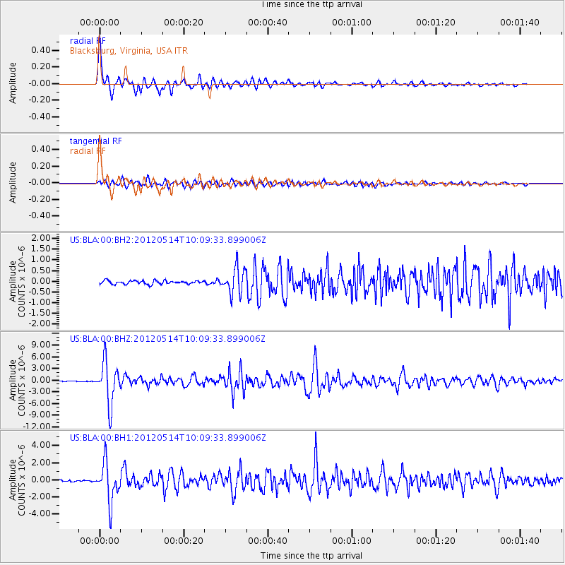
Signal To Noise
| Channel | StoN | STA | LTA |
| US:BLA:00:BHZ:20120514T10:09:33.899006Z | 49.297733 | 5.4896004E-6 | 1.11356044E-7 |
| US:BLA:00:BH1:20120514T10:09:33.899006Z | 25.598734 | 2.3253322E-6 | 9.083778E-8 |
| US:BLA:00:BH2:20120514T10:09:33.899006Z | 8.116173 | 6.2554466E-7 | 7.707384E-8 |
| Arrivals |
| Ps | 4.5 SECOND |
| PpPs | 13 SECOND |
| PsPs/PpSs | 17 SECOND |


