You are here: Home > Network List > US - United States National Seismic Network Stations List
> Station DGMT Dagmar, Montana, USA > Earthquake Result Viewer
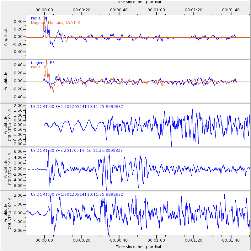
DGMT Dagmar, Montana, USA - Earthquake Result Viewer
*The percent match for this event was below the threshold and hence no stack was calculated.
| Earthquake location: |
Peru-Bolivia Border Region |
| Earthquake latitude/longitude: |
-17.7/-69.6 |
| Earthquake time(UTC): |
2012/05/14 (135) 10:00:40 GMT |
| Earthquake Depth: |
106 km |
| Earthquake Magnitude: |
6.4 MB, 6.2 MW, 6.2 MW |
| Earthquake Catalog/Contributor: |
WHDF/NEIC |
|
| Network: |
US United States National Seismic Network |
| Station: |
DGMT Dagmar, Montana, USA |
| Lat/Lon: |
48.47 N/104.20 W |
| Elevation: |
0.0 m |
|
| Distance: |
72.7 deg |
| Az: |
336.684 deg |
| Baz: |
145.459 deg |
| Ray Param: |
$rayparam |
*The percent match for this event was below the threshold and hence was not used in the summary stack. |
|
| Radial Match: |
84.26342 % |
| Radial Bump: |
400 |
| Transverse Match: |
78.862076 % |
| Transverse Bump: |
400 |
| SOD ConfigId: |
558545 |
| Insert Time: |
2013-09-19 18:30:39.222 +0000 |
| GWidth: |
2.5 |
| Max Bumps: |
400 |
| Tol: |
0.001 |
|
Signal To Noise
| Channel | StoN | STA | LTA |
| US:DGMT:00:BHZ:20120514T10:11:25.899983Z | 22.921286 | 2.6549596E-6 | 1.15829444E-7 |
| US:DGMT:00:BH1:20120514T10:11:25.899983Z | 3.0088544 | 7.1278913E-7 | 2.368972E-7 |
| US:DGMT:00:BH2:20120514T10:11:25.899983Z | 1.5559069 | 5.147836E-7 | 3.3085757E-7 |
| Arrivals |
| Ps | |
| PpPs | |
| PsPs/PpSs | |


