You are here: Home > Network List > US - United States National Seismic Network Stations List
> Station OXF Oxford, Mississippi, USA > Earthquake Result Viewer
OXF Oxford, Mississippi, USA - Earthquake Result Viewer

| Earthquake location: |
Peru-Bolivia Border Region |
| Earthquake latitude/longitude: |
-17.7/-69.6 |
| Earthquake time(UTC): |
2012/05/14 (135) 10:00:40 GMT |
| Earthquake Depth: |
106 km |
| Earthquake Magnitude: |
6.4 MB, 6.2 MW, 6.2 MW |
| Earthquake Catalog/Contributor: |
WHDF/NEIC |
|
| Network: |
US United States National Seismic Network |
| Station: |
OXF Oxford, Mississippi, USA |
| Lat/Lon: |
34.51 N/89.41 W |
| Elevation: |
101 m |
|
| Distance: |
55.2 deg |
| Az: |
340.071 deg |
| Baz: |
156.826 deg |
| Ray Param: |
0.06461053 |
| Estimated Moho Depth: |
10.0 km |
| Estimated Crust Vp/Vs: |
1.60 |
| Assumed Crust Vp: |
6.38 km/s |
| Estimated Crust Vs: |
3.988 km/s |
| Estimated Crust Poisson's Ratio: |
0.18 |
|
| Radial Match: |
92.3736 % |
| Radial Bump: |
400 |
| Transverse Match: |
72.56967 % |
| Transverse Bump: |
400 |
| SOD ConfigId: |
558545 |
| Insert Time: |
2013-09-19 18:31:59.987 +0000 |
| GWidth: |
2.5 |
| Max Bumps: |
400 |
| Tol: |
0.001 |
|
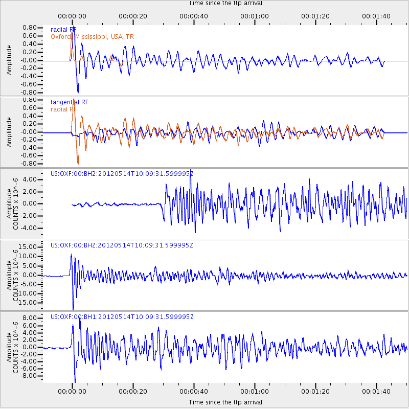
Signal To Noise
| Channel | StoN | STA | LTA |
| US:OXF:00:BHZ:20120514T10:09:31.599995Z | 103.61099 | 6.956953E-6 | 6.714493E-8 |
| US:OXF:00:BH1:20120514T10:09:31.599995Z | 37.53746 | 4.358761E-6 | 1.1611764E-7 |
| US:OXF:00:BH2:20120514T10:09:31.599995Z | 12.654271 | 1.7116674E-6 | 1.35264E-7 |
| Arrivals |
| Ps | 1.0 SECOND |
| PpPs | 3.9 SECOND |
| PsPs/PpSs | 4.8 SECOND |


