You are here: Home > Network List > US - United States National Seismic Network Stations List
> Station PKME Peaks-Kenny State Park, Maine, USA > Earthquake Result Viewer
PKME Peaks-Kenny State Park, Maine, USA - Earthquake Result Viewer
| Earthquake location: |
Peru-Bolivia Border Region |
| Earthquake latitude/longitude: |
-17.7/-69.6 |
| Earthquake time(UTC): |
2012/05/14 (135) 10:00:40 GMT |
| Earthquake Depth: |
106 km |
| Earthquake Magnitude: |
6.4 MB, 6.2 MW, 6.2 MW |
| Earthquake Catalog/Contributor: |
WHDF/NEIC |
|
| Network: |
US United States National Seismic Network |
| Station: |
PKME Peaks-Kenny State Park, Maine, USA |
| Lat/Lon: |
45.26 N/69.29 W |
| Elevation: |
108 m |
|
| Distance: |
62.6 deg |
| Az: |
0.238 deg |
| Baz: |
180.321 deg |
| Ray Param: |
0.05980273 |
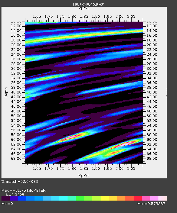
| Estimated Moho Depth: |
61.75 km |
| Estimated Crust Vp/Vs: |
2.02 |
| Assumed Crust Vp: |
6.419 km/s |
| Estimated Crust Vs: |
3.174 km/s |
| Estimated Crust Poisson's Ratio: |
0.34 |
|
| Radial Match: |
92.64083 % |
| Radial Bump: |
346 |
| Transverse Match: |
83.48097 % |
| Transverse Bump: |
400 |
| SOD ConfigId: |
558545 |
| Insert Time: |
2013-09-19 18:32:05.155 +0000 |
| GWidth: |
2.5 |
| Max Bumps: |
400 |
| Tol: |
0.001 |
|
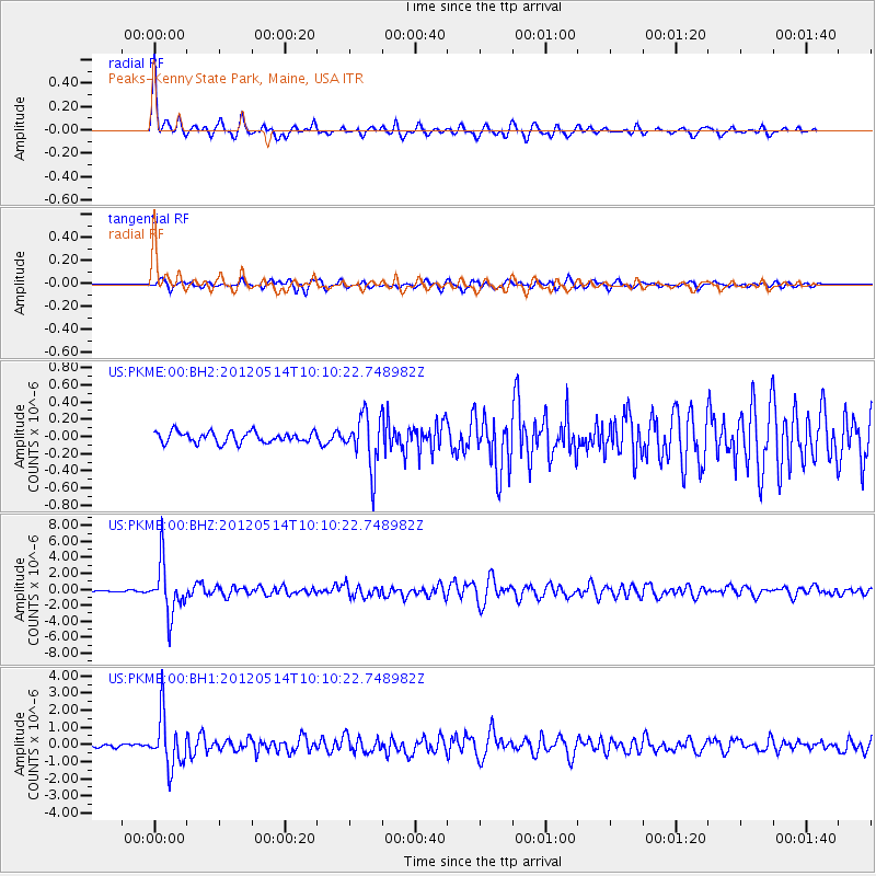
Signal To Noise
| Channel | StoN | STA | LTA |
| US:PKME:00:BHZ:20120514T10:10:22.748982Z | 33.952904 | 3.2140051E-6 | 9.466069E-8 |
| US:PKME:00:BH1:20120514T10:10:22.748982Z | 18.22847 | 1.501439E-6 | 8.23678E-8 |
| US:PKME:00:BH2:20120514T10:10:22.748982Z | 4.6847415 | 2.9807586E-7 | 6.3626956E-8 |
| Arrivals |
| Ps | 10 SECOND |
| PpPs | 28 SECOND |
| PsPs/PpSs | 38 SECOND |


