You are here: Home > Network List > US - United States National Seismic Network Stations List
> Station AMTX Amarillo, Texas, USA > Earthquake Result Viewer
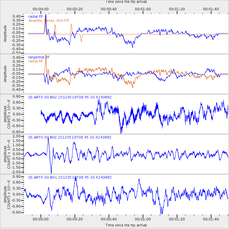
AMTX Amarillo, Texas, USA - Earthquake Result Viewer
*The percent match for this event was below the threshold and hence no stack was calculated.
| Earthquake location: |
Near Coast Of Northern Chile |
| Earthquake latitude/longitude: |
-25.7/-70.6 |
| Earthquake time(UTC): |
2012/05/19 (140) 08:35:10 GMT |
| Earthquake Depth: |
28 km |
| Earthquake Magnitude: |
5.7 MB, 5.5 MS, 5.8 MW, 5.9 MW |
| Earthquake Catalog/Contributor: |
WHDF/NEIC |
|
| Network: |
US United States National Seismic Network |
| Station: |
AMTX Amarillo, Texas, USA |
| Lat/Lon: |
34.53 N/101.41 W |
| Elevation: |
1010 m |
|
| Distance: |
66.7 deg |
| Az: |
332.552 deg |
| Baz: |
149.762 deg |
| Ray Param: |
$rayparam |
*The percent match for this event was below the threshold and hence was not used in the summary stack. |
|
| Radial Match: |
71.93785 % |
| Radial Bump: |
400 |
| Transverse Match: |
56.514706 % |
| Transverse Bump: |
400 |
| SOD ConfigId: |
558545 |
| Insert Time: |
2013-09-19 18:40:24.058 +0000 |
| GWidth: |
2.5 |
| Max Bumps: |
400 |
| Tol: |
0.001 |
|
Signal To Noise
| Channel | StoN | STA | LTA |
| US:AMTX:00:BHZ:20120519T08:45:30.624988Z | 5.57242 | 6.3114277E-7 | 1.13261876E-7 |
| US:AMTX:00:BH1:20120519T08:45:30.624988Z | 2.150516 | 2.6074306E-7 | 1.2124674E-7 |
| US:AMTX:00:BH2:20120519T08:45:30.624988Z | 1.158945 | 1.7157741E-7 | 1.4804621E-7 |
| Arrivals |
| Ps | |
| PpPs | |
| PsPs/PpSs | |


