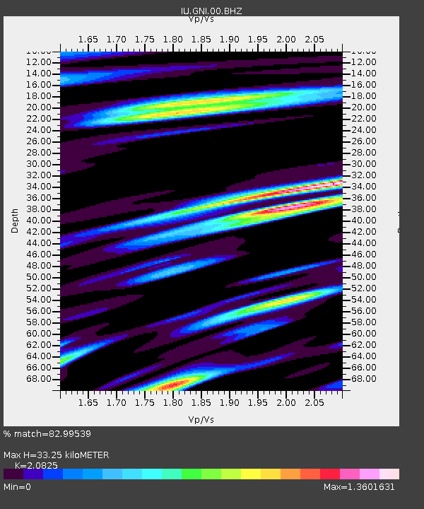
GNI Garni, Armenia - Earthquake Result Viewer
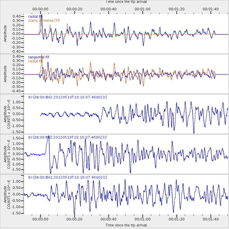
Earthquake location: Off East Coast Of Honshu, Japan
Earthquake latitude/longitude: 39.7/143.3
Earthquake time(UTC): 2012/05/19 (140) 19:05:18 GMT
Earthquake Depth: 10 km
Earthquake Magnitude: 5.6 MB, 5.5 MS, 5.9 MW, 5.8 MW
Earthquake Catalog/Contributor: WHDF/NEIC
Network: IU Global Seismograph Network (GSN - IRIS/USGS)
Station: GNI Garni, Armenia
Lat/Lon: 40.15 N/44.74 E
Elevation: 1609 m
Distance: 71.3 deg
Az: 306.864 deg
Baz: 53.675 deg
Ray Param: 0.05440119
Estimated Moho Depth: 33.25 km
Estimated Crust Vp/Vs: 2.08
Assumed Crust Vp: 6.291 km/s
Estimated Crust Vs: 3.021 km/s
Estimated Crust Poisson's Ratio: 0.35
Radial Match: 82.99539 %
Radial Bump: 400
Transverse Match: 75.52889 %
Transverse Bump: 400
SOD ConfigId: 558545
Insert Time: 2013-09-19 18:44:14.740 +0000
GWidth: 2.5
Max Bumps: 400
Tol: 0.001

Signal To Noise

ChannelStoNSTALTA
IU:GNI:00:BHZ:20120519T19:16:07.469023Z8.2180137.108598E-78.650021E-8
IU:GNI:00:BH1:20120519T19:16:07.469023Z1.74659691.29545E-77.416995E-8
IU:GNI:00:BH2:20120519T19:16:07.469023Z1.68871251.7539982E-71.03866014E-7
Arrivals
Ps5.9 SECOND
PpPs16 SECOND
PsPs/PpSs22 SECOND