You are here: Home > Network List > IU - Global Seismograph Network (GSN - IRIS/USGS) Stations List
> Station RSSD Black Hills, South Dakota, USA > Earthquake Result Viewer
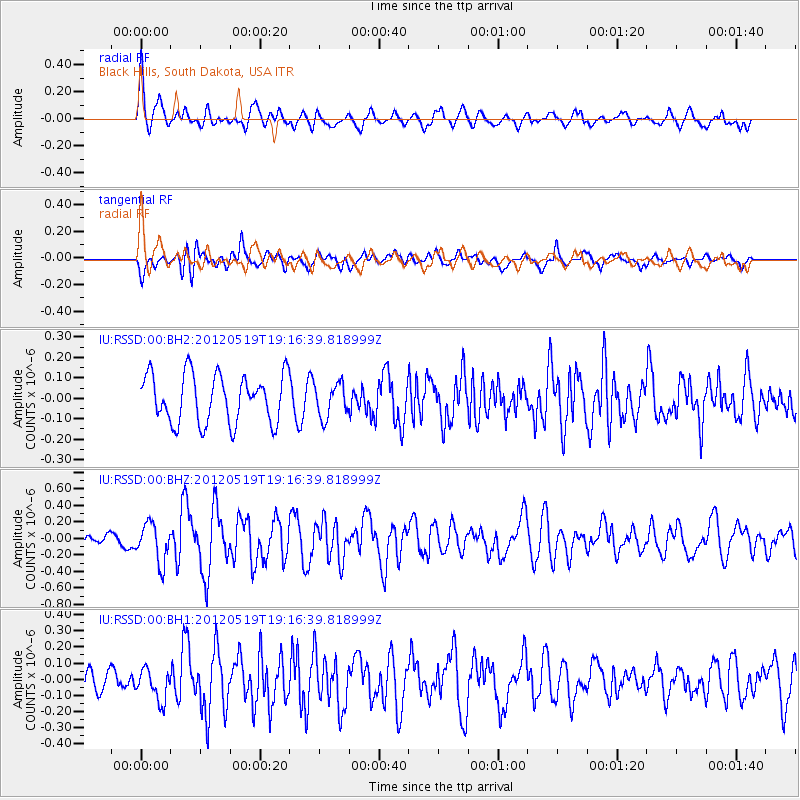
RSSD Black Hills, South Dakota, USA - Earthquake Result Viewer
*The percent match for this event was below the threshold and hence no stack was calculated.
| Earthquake location: |
Off East Coast Of Honshu, Japan |
| Earthquake latitude/longitude: |
39.7/143.3 |
| Earthquake time(UTC): |
2012/05/19 (140) 19:05:18 GMT |
| Earthquake Depth: |
10 km |
| Earthquake Magnitude: |
5.6 MB, 5.5 MS, 5.9 MW, 5.8 MW |
| Earthquake Catalog/Contributor: |
WHDF/NEIC |
|
| Network: |
IU Global Seismograph Network (GSN - IRIS/USGS) |
| Station: |
RSSD Black Hills, South Dakota, USA |
| Lat/Lon: |
44.12 N/104.04 W |
| Elevation: |
2090 m |
|
| Distance: |
76.9 deg |
| Az: |
43.035 deg |
| Baz: |
312.994 deg |
| Ray Param: |
$rayparam |
*The percent match for this event was below the threshold and hence was not used in the summary stack. |
|
| Radial Match: |
78.250885 % |
| Radial Bump: |
400 |
| Transverse Match: |
71.22567 % |
| Transverse Bump: |
400 |
| SOD ConfigId: |
558545 |
| Insert Time: |
2013-09-19 18:44:42.415 +0000 |
| GWidth: |
2.5 |
| Max Bumps: |
400 |
| Tol: |
0.001 |
|
Signal To Noise
| Channel | StoN | STA | LTA |
| IU:RSSD:00:BHZ:20120519T19:16:39.818999Z | 2.0964544 | 2.3487398E-7 | 1.1203391E-7 |
| IU:RSSD:00:BH1:20120519T19:16:39.818999Z | 1.252246 | 9.778928E-8 | 7.809111E-8 |
| IU:RSSD:00:BH2:20120519T19:16:39.818999Z | 0.70219344 | 8.310313E-8 | 1.1834793E-7 |
| Arrivals |
| Ps | |
| PpPs | |
| PsPs/PpSs | |


