You are here: Home > Network List > KZ - Kazakhstan Network Stations List
> Station KUR21 Cross-array, Kurchatov, Kazakstan > Earthquake Result Viewer
KUR21 Cross-array, Kurchatov, Kazakstan - Earthquake Result Viewer
| Earthquake location: |
Off East Coast Of Honshu, Japan |
| Earthquake latitude/longitude: |
39.5/143.2 |
| Earthquake time(UTC): |
2012/05/20 (141) 07:19:54 GMT |
| Earthquake Depth: |
11 km |
| Earthquake Magnitude: |
5.6 MB |
| Earthquake Catalog/Contributor: |
WHDF/NEIC |
|
| Network: |
KZ Kazakhstan Network |
| Station: |
KUR21 Cross-array, Kurchatov, Kazakstan |
| Lat/Lon: |
50.62 N/78.53 E |
| Elevation: |
200 m |
|
| Distance: |
45.6 deg |
| Az: |
306.328 deg |
| Baz: |
77.938 deg |
| Ray Param: |
0.07114512 |
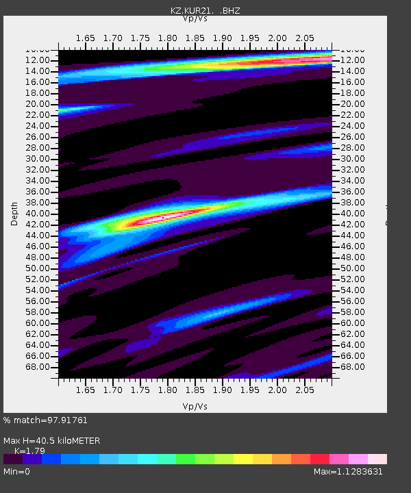
| Estimated Moho Depth: |
40.5 km |
| Estimated Crust Vp/Vs: |
1.79 |
| Assumed Crust Vp: |
6.552 km/s |
| Estimated Crust Vs: |
3.661 km/s |
| Estimated Crust Poisson's Ratio: |
0.27 |
|
| Radial Match: |
97.91761 % |
| Radial Bump: |
400 |
| Transverse Match: |
97.88091 % |
| Transverse Bump: |
293 |
| SOD ConfigId: |
558545 |
| Insert Time: |
2013-09-19 18:52:56.235 +0000 |
| GWidth: |
2.5 |
| Max Bumps: |
400 |
| Tol: |
0.001 |
|

Signal To Noise
| Channel | StoN | STA | LTA |
| KZ:KUR21: :BHZ:20120520T07:27:44.326014Z | 29.373476 | 1.6874633E-6 | 5.7448535E-8 |
| KZ:KUR21: :BH1:20120520T07:27:44.326014Z | 12.7651205 | 9.154403E-7 | 7.171419E-8 |
| KZ:KUR21: :BH2:20120520T07:27:44.326014Z | 1.5133051 | 1.1573458E-7 | 7.6478024E-8 |
| Arrivals |
| Ps | 5.2 SECOND |
| PpPs | 16 SECOND |
| PsPs/PpSs | 21 SECOND |


