You are here: Home > Network List > US - United States National Seismic Network Stations List
> Station DGMT Dagmar, Montana, USA > Earthquake Result Viewer
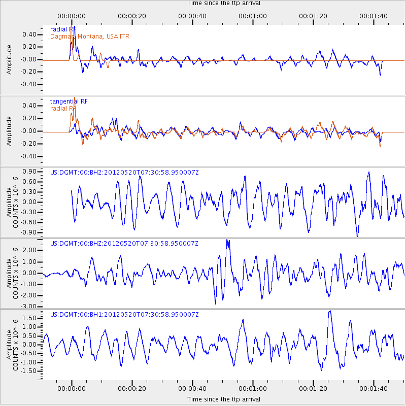
DGMT Dagmar, Montana, USA - Earthquake Result Viewer
*The percent match for this event was below the threshold and hence no stack was calculated.
| Earthquake location: |
Off East Coast Of Honshu, Japan |
| Earthquake latitude/longitude: |
39.5/143.2 |
| Earthquake time(UTC): |
2012/05/20 (141) 07:19:54 GMT |
| Earthquake Depth: |
11 km |
| Earthquake Magnitude: |
5.6 MB |
| Earthquake Catalog/Contributor: |
WHDF/NEIC |
|
| Network: |
US United States National Seismic Network |
| Station: |
DGMT Dagmar, Montana, USA |
| Lat/Lon: |
48.47 N/104.20 W |
| Elevation: |
0.0 m |
|
| Distance: |
74.0 deg |
| Az: |
39.749 deg |
| Baz: |
312.022 deg |
| Ray Param: |
$rayparam |
*The percent match for this event was below the threshold and hence was not used in the summary stack. |
|
| Radial Match: |
68.5016 % |
| Radial Bump: |
392 |
| Transverse Match: |
55.847878 % |
| Transverse Bump: |
400 |
| SOD ConfigId: |
558545 |
| Insert Time: |
2013-09-19 18:53:22.603 +0000 |
| GWidth: |
2.5 |
| Max Bumps: |
400 |
| Tol: |
0.001 |
|
Signal To Noise
| Channel | StoN | STA | LTA |
| US:DGMT:00:BHZ:20120520T07:30:58.950007Z | 4.273859 | 4.140136E-7 | 9.687115E-8 |
| US:DGMT:00:BH1:20120520T07:30:58.950007Z | 0.83214945 | 4.1843316E-7 | 5.0283415E-7 |
| US:DGMT:00:BH2:20120520T07:30:58.950007Z | 1.0703523 | 3.8499363E-7 | 3.5968867E-7 |
| Arrivals |
| Ps | |
| PpPs | |
| PsPs/PpSs | |


