You are here: Home > Network List > IU - Global Seismograph Network (GSN - IRIS/USGS) Stations List
> Station ANMO Albuquerque, New Mexico, USA > Earthquake Result Viewer
ANMO Albuquerque, New Mexico, USA - Earthquake Result Viewer
| Earthquake location: |
Hokkaido, Japan Region |
| Earthquake latitude/longitude: |
41.3/142.1 |
| Earthquake time(UTC): |
2012/05/23 (144) 15:02:25 GMT |
| Earthquake Depth: |
46 km |
| Earthquake Magnitude: |
6.2 MB, 5.5 MS, 5.9 MW, 6.0 MW |
| Earthquake Catalog/Contributor: |
WHDF/NEIC |
|
| Network: |
IU Global Seismograph Network (GSN - IRIS/USGS) |
| Station: |
ANMO Albuquerque, New Mexico, USA |
| Lat/Lon: |
34.95 N/106.46 W |
| Elevation: |
1820 m |
|
| Distance: |
81.4 deg |
| Az: |
50.638 deg |
| Baz: |
314.868 deg |
| Ray Param: |
0.047506772 |
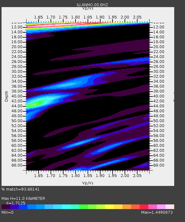
| Estimated Moho Depth: |
11.0 km |
| Estimated Crust Vp/Vs: |
1.71 |
| Assumed Crust Vp: |
6.502 km/s |
| Estimated Crust Vs: |
3.797 km/s |
| Estimated Crust Poisson's Ratio: |
0.24 |
|
| Radial Match: |
93.68141 % |
| Radial Bump: |
333 |
| Transverse Match: |
82.17088 % |
| Transverse Bump: |
400 |
| SOD ConfigId: |
558545 |
| Insert Time: |
2013-09-19 19:00:21.898 +0000 |
| GWidth: |
2.5 |
| Max Bumps: |
400 |
| Tol: |
0.001 |
|

Signal To Noise
| Channel | StoN | STA | LTA |
| IU:ANMO:00:BHZ:20120523T15:14:06.419009Z | 10.296744 | 4.7877984E-7 | 4.649818E-8 |
| IU:ANMO:00:BH1:20120523T15:14:06.419009Z | 3.3094702 | 1.3028918E-7 | 3.936859E-8 |
| IU:ANMO:00:BH2:20120523T15:14:06.419009Z | 2.3617494 | 9.697459E-8 | 4.106049E-8 |
| Arrivals |
| Ps | 1.2 SECOND |
| PpPs | 4.5 SECOND |
| PsPs/PpSs | 5.7 SECOND |


