You are here: Home > Network List > US - United States National Seismic Network Stations List
> Station AMTX Amarillo, Texas, USA > Earthquake Result Viewer
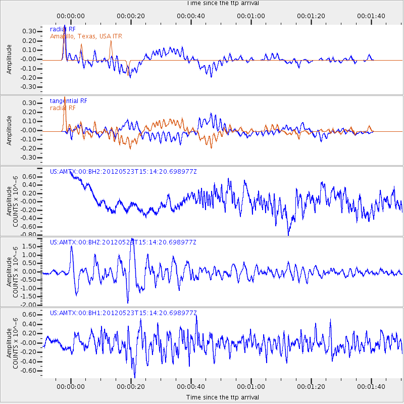
AMTX Amarillo, Texas, USA - Earthquake Result Viewer
*The percent match for this event was below the threshold and hence no stack was calculated.
| Earthquake location: |
Hokkaido, Japan Region |
| Earthquake latitude/longitude: |
41.3/142.1 |
| Earthquake time(UTC): |
2012/05/23 (144) 15:02:25 GMT |
| Earthquake Depth: |
46 km |
| Earthquake Magnitude: |
6.2 MB, 5.5 MS, 5.9 MW, 6.0 MW |
| Earthquake Catalog/Contributor: |
WHDF/NEIC |
|
| Network: |
US United States National Seismic Network |
| Station: |
AMTX Amarillo, Texas, USA |
| Lat/Lon: |
34.53 N/101.41 W |
| Elevation: |
1010 m |
|
| Distance: |
84.6 deg |
| Az: |
47.908 deg |
| Baz: |
317.401 deg |
| Ray Param: |
$rayparam |
*The percent match for this event was below the threshold and hence was not used in the summary stack. |
|
| Radial Match: |
58.633476 % |
| Radial Bump: |
400 |
| Transverse Match: |
40.600704 % |
| Transverse Bump: |
400 |
| SOD ConfigId: |
558545 |
| Insert Time: |
2013-09-19 19:01:35.086 +0000 |
| GWidth: |
2.5 |
| Max Bumps: |
400 |
| Tol: |
0.001 |
|
Signal To Noise
| Channel | StoN | STA | LTA |
| US:AMTX:00:BHZ:20120523T15:14:20.698977Z | 10.091043 | 7.6271465E-7 | 7.558333E-8 |
| US:AMTX:00:BH1:20120523T15:14:20.698977Z | 1.8333939 | 1.3692264E-7 | 7.46826E-8 |
| US:AMTX:00:BH2:20120523T15:14:20.698977Z | 0.5420185 | 1.3464003E-7 | 2.484049E-7 |
| Arrivals |
| Ps | |
| PpPs | |
| PsPs/PpSs | |


