You are here: Home > Network List > US - United States National Seismic Network Stations List
> Station DGMT Dagmar, Montana, USA > Earthquake Result Viewer
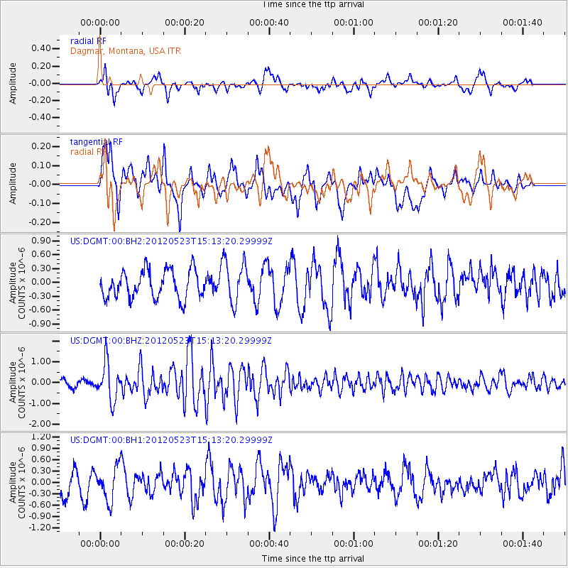
DGMT Dagmar, Montana, USA - Earthquake Result Viewer
*The percent match for this event was below the threshold and hence no stack was calculated.
| Earthquake location: |
Hokkaido, Japan Region |
| Earthquake latitude/longitude: |
41.3/142.1 |
| Earthquake time(UTC): |
2012/05/23 (144) 15:02:25 GMT |
| Earthquake Depth: |
46 km |
| Earthquake Magnitude: |
6.2 MB, 5.5 MS, 5.9 MW, 6.0 MW |
| Earthquake Catalog/Contributor: |
WHDF/NEIC |
|
| Network: |
US United States National Seismic Network |
| Station: |
DGMT Dagmar, Montana, USA |
| Lat/Lon: |
48.47 N/104.20 W |
| Elevation: |
0.0 m |
|
| Distance: |
73.2 deg |
| Az: |
39.533 deg |
| Baz: |
313.924 deg |
| Ray Param: |
$rayparam |
*The percent match for this event was below the threshold and hence was not used in the summary stack. |
|
| Radial Match: |
53.996986 % |
| Radial Bump: |
400 |
| Transverse Match: |
62.44028 % |
| Transverse Bump: |
400 |
| SOD ConfigId: |
558545 |
| Insert Time: |
2013-09-19 19:01:56.643 +0000 |
| GWidth: |
2.5 |
| Max Bumps: |
400 |
| Tol: |
0.001 |
|
Signal To Noise
| Channel | StoN | STA | LTA |
| US:DGMT:00:BHZ:20120523T15:13:20.29999Z | 4.1520863 | 9.192332E-7 | 2.2139068E-7 |
| US:DGMT:00:BH1:20120523T15:13:20.29999Z | 1.7598802 | 4.649547E-7 | 2.6419679E-7 |
| US:DGMT:00:BH2:20120523T15:13:20.29999Z | 1.5862375 | 4.7348172E-7 | 2.9849357E-7 |
| Arrivals |
| Ps | |
| PpPs | |
| PsPs/PpSs | |


