You are here: Home > Network List > TA - USArray Transportable Network (new EarthScope stations) Stations List
> Station X43A Marvell, AR, USA > Earthquake Result Viewer
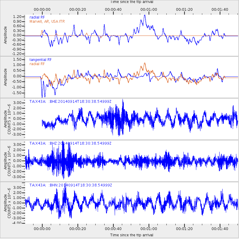
X43A Marvell, AR, USA - Earthquake Result Viewer
*The percent match for this event was below the threshold and hence no stack was calculated.
| Earthquake location: |
Tonga Islands |
| Earthquake latitude/longitude: |
-21.4/-174.4 |
| Earthquake time(UTC): |
2014/09/14 (257) 18:17:44 GMT |
| Earthquake Depth: |
49 km |
| Earthquake Magnitude: |
5.7 MW |
| Earthquake Catalog/Contributor: |
ISC/ISC |
|
| Network: |
TA USArray Transportable Network (new EarthScope stations) |
| Station: |
X43A Marvell, AR, USA |
| Lat/Lon: |
34.52 N/90.88 W |
| Elevation: |
53 m |
|
| Distance: |
96.8 deg |
| Az: |
55.717 deg |
| Baz: |
248.854 deg |
| Ray Param: |
$rayparam |
*The percent match for this event was below the threshold and hence was not used in the summary stack. |
|
| Radial Match: |
40.957375 % |
| Radial Bump: |
400 |
| Transverse Match: |
45.519753 % |
| Transverse Bump: |
400 |
| SOD ConfigId: |
3390531 |
| Insert Time: |
2019-04-14 01:24:45.490 +0000 |
| GWidth: |
2.5 |
| Max Bumps: |
400 |
| Tol: |
0.001 |
|
Signal To Noise
| Channel | StoN | STA | LTA |
| TA:X43A: :BHZ:20140914T18:30:38.54999Z | 0.9347727 | 6.265174E-7 | 6.70235E-7 |
| TA:X43A: :BHN:20140914T18:30:38.54999Z | 1.1918702 | 7.8987216E-7 | 6.627166E-7 |
| TA:X43A: :BHE:20140914T18:30:38.54999Z | 1.0361446 | 8.5302827E-7 | 8.232714E-7 |
| Arrivals |
| Ps | |
| PpPs | |
| PsPs/PpSs | |


