You are here: Home > Network List > IU - Global Seismograph Network (GSN - IRIS/USGS) Stations List
> Station PAYG Puerto Ayora, Galapagos Islands > Earthquake Result Viewer
PAYG Puerto Ayora, Galapagos Islands - Earthquake Result Viewer
| Earthquake location: |
Santiago Del Estero Prov., Arg. |
| Earthquake latitude/longitude: |
-28.0/-63.1 |
| Earthquake time(UTC): |
2012/05/28 (149) 05:07:23 GMT |
| Earthquake Depth: |
587 km |
| Earthquake Magnitude: |
6.0 MB, 6.7 MW, 6.8 MW |
| Earthquake Catalog/Contributor: |
WHDF/NEIC |
|
| Network: |
IU Global Seismograph Network (GSN - IRIS/USGS) |
| Station: |
PAYG Puerto Ayora, Galapagos Islands |
| Lat/Lon: |
0.67 S/90.29 W |
| Elevation: |
270 m |
|
| Distance: |
37.7 deg |
| Az: |
311.595 deg |
| Baz: |
138.618 deg |
| Ray Param: |
0.07299408 |
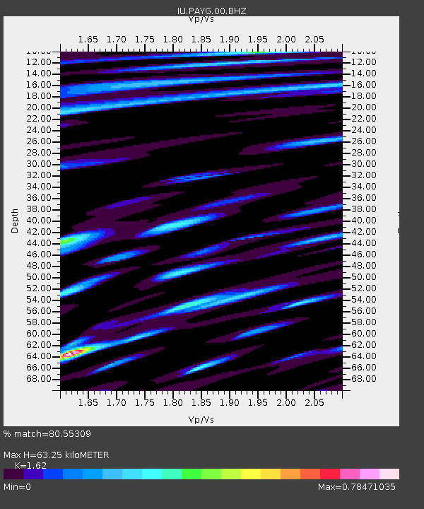
| Estimated Moho Depth: |
63.25 km |
| Estimated Crust Vp/Vs: |
1.62 |
| Assumed Crust Vp: |
4.802 km/s |
| Estimated Crust Vs: |
2.964 km/s |
| Estimated Crust Poisson's Ratio: |
0.19 |
|
| Radial Match: |
80.55309 % |
| Radial Bump: |
400 |
| Transverse Match: |
70.25496 % |
| Transverse Bump: |
400 |
| SOD ConfigId: |
558545 |
| Insert Time: |
2013-09-19 19:15:12.989 +0000 |
| GWidth: |
2.5 |
| Max Bumps: |
400 |
| Tol: |
0.001 |
|
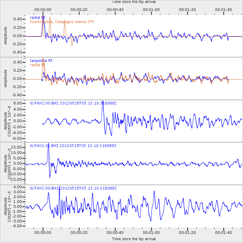
Signal To Noise
| Channel | StoN | STA | LTA |
| IU:PAYG:00:BHZ:20120528T05:13:19.318988Z | 12.399375 | 6.9405837E-6 | 5.597527E-7 |
| IU:PAYG:00:BH1:20120528T05:13:19.318988Z | 2.7025738 | 1.1221937E-6 | 4.1523148E-7 |
| IU:PAYG:00:BH2:20120528T05:13:19.318988Z | 4.614248 | 2.7655842E-6 | 5.993575E-7 |
| Arrivals |
| Ps | 8.5 SECOND |
| PpPs | 33 SECOND |
| PsPs/PpSs | 42 SECOND |


