You are here: Home > Network List > US - United States National Seismic Network Stations List
> Station DGMT Dagmar, Montana, USA > Earthquake Result Viewer
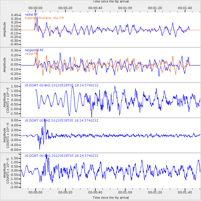
DGMT Dagmar, Montana, USA - Earthquake Result Viewer
*The percent match for this event was below the threshold and hence no stack was calculated.
| Earthquake location: |
Santiago Del Estero Prov., Arg. |
| Earthquake latitude/longitude: |
-28.0/-63.1 |
| Earthquake time(UTC): |
2012/05/28 (149) 05:07:23 GMT |
| Earthquake Depth: |
587 km |
| Earthquake Magnitude: |
6.0 MB, 6.7 MW, 6.8 MW |
| Earthquake Catalog/Contributor: |
WHDF/NEIC |
|
| Network: |
US United States National Seismic Network |
| Station: |
DGMT Dagmar, Montana, USA |
| Lat/Lon: |
48.47 N/104.20 W |
| Elevation: |
0.0 m |
|
| Distance: |
84.6 deg |
| Az: |
333.931 deg |
| Baz: |
144.291 deg |
| Ray Param: |
$rayparam |
*The percent match for this event was below the threshold and hence was not used in the summary stack. |
|
| Radial Match: |
68.307465 % |
| Radial Bump: |
386 |
| Transverse Match: |
48.547077 % |
| Transverse Bump: |
350 |
| SOD ConfigId: |
558545 |
| Insert Time: |
2013-09-19 19:16:22.442 +0000 |
| GWidth: |
2.5 |
| Max Bumps: |
400 |
| Tol: |
0.001 |
|
Signal To Noise
| Channel | StoN | STA | LTA |
| US:DGMT:00:BHZ:20120528T05:18:24.574023Z | 11.676332 | 1.8549232E-6 | 1.588618E-7 |
| US:DGMT:00:BH1:20120528T05:18:24.574023Z | 0.83771676 | 5.832635E-7 | 6.962539E-7 |
| US:DGMT:00:BH2:20120528T05:18:24.574023Z | 0.79375446 | 5.2115206E-7 | 6.565659E-7 |
| Arrivals |
| Ps | |
| PpPs | |
| PsPs/PpSs | |


