You are here: Home > Network List > UW - Pacific Northwest Regional Seismic Network Stations List
> Station MRBL Marblemount, WA, USA > Earthquake Result Viewer
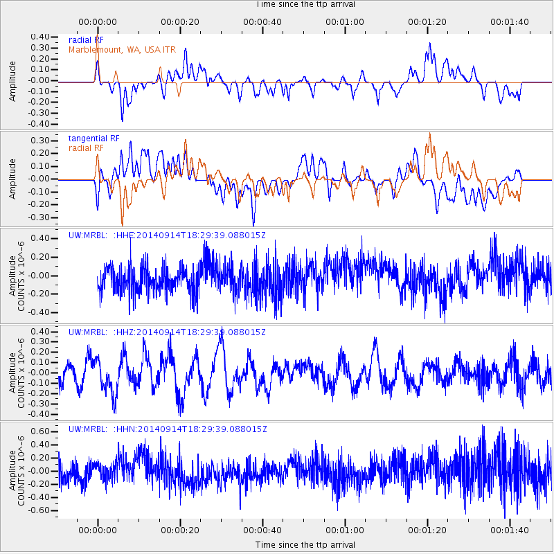
MRBL Marblemount, WA, USA - Earthquake Result Viewer
*The percent match for this event was below the threshold and hence no stack was calculated.
| Earthquake location: |
Tonga Islands |
| Earthquake latitude/longitude: |
-21.4/-174.4 |
| Earthquake time(UTC): |
2014/09/14 (257) 18:17:44 GMT |
| Earthquake Depth: |
49 km |
| Earthquake Magnitude: |
5.7 MW |
| Earthquake Catalog/Contributor: |
ISC/ISC |
|
| Network: |
UW Pacific Northwest Regional Seismic Network |
| Station: |
MRBL Marblemount, WA, USA |
| Lat/Lon: |
48.52 N/121.48 W |
| Elevation: |
75 m |
|
| Distance: |
84.1 deg |
| Az: |
32.239 deg |
| Baz: |
228.402 deg |
| Ray Param: |
$rayparam |
*The percent match for this event was below the threshold and hence was not used in the summary stack. |
|
| Radial Match: |
57.1723 % |
| Radial Bump: |
400 |
| Transverse Match: |
35.369057 % |
| Transverse Bump: |
400 |
| SOD ConfigId: |
3390531 |
| Insert Time: |
2019-04-14 01:25:29.252 +0000 |
| GWidth: |
2.5 |
| Max Bumps: |
400 |
| Tol: |
0.001 |
|
Signal To Noise
| Channel | StoN | STA | LTA |
| UW:MRBL: :HHZ:20140914T18:29:39.088015Z | 1.9889576 | 1.7176478E-7 | 8.63592E-8 |
| UW:MRBL: :HHN:20140914T18:29:39.088015Z | 0.8976927 | 1.2036598E-7 | 1.3408372E-7 |
| UW:MRBL: :HHE:20140914T18:29:39.088015Z | 1.0571296 | 1.3600169E-7 | 1.2865186E-7 |
| Arrivals |
| Ps | |
| PpPs | |
| PsPs/PpSs | |


