You are here: Home > Network List > II - Global Seismograph Network (GSN - IRIS/IDA) Stations List
> Station EFI Mount Kent, East Falkland Island > Earthquake Result Viewer
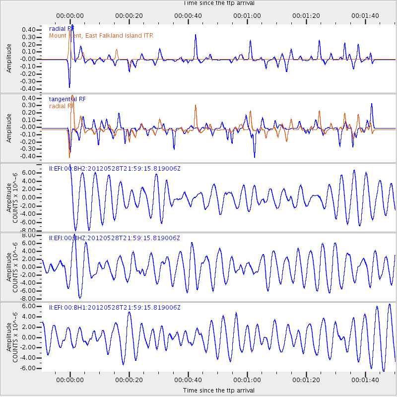
EFI Mount Kent, East Falkland Island - Earthquake Result Viewer
*The percent match for this event was below the threshold and hence no stack was calculated.
| Earthquake location: |
Tonga Islands |
| Earthquake latitude/longitude: |
-20.0/-176.0 |
| Earthquake time(UTC): |
2012/05/28 (149) 21:47:09 GMT |
| Earthquake Depth: |
211 km |
| Earthquake Magnitude: |
5.9 MW, 5.3 MB, 5.9 MW |
| Earthquake Catalog/Contributor: |
WHDF/NEIC |
|
| Network: |
II Global Seismograph Network (GSN - IRIS/IDA) |
| Station: |
EFI Mount Kent, East Falkland Island |
| Lat/Lon: |
51.68 S/58.06 W |
| Elevation: |
110 m |
|
| Distance: |
90.5 deg |
| Az: |
146.615 deg |
| Baz: |
236.228 deg |
| Ray Param: |
$rayparam |
*The percent match for this event was below the threshold and hence was not used in the summary stack. |
|
| Radial Match: |
65.01031 % |
| Radial Bump: |
338 |
| Transverse Match: |
68.389694 % |
| Transverse Bump: |
355 |
| SOD ConfigId: |
558545 |
| Insert Time: |
2013-09-19 19:19:16.576 +0000 |
| GWidth: |
2.5 |
| Max Bumps: |
400 |
| Tol: |
0.001 |
|
Signal To Noise
| Channel | StoN | STA | LTA |
| II:EFI:00:BHZ:20120528T21:59:15.819006Z | 2.4694145 | 5.2886503E-6 | 2.1416618E-6 |
| II:EFI:00:BH1:20120528T21:59:15.819006Z | 0.48212248 | 1.4258248E-6 | 2.9573912E-6 |
| II:EFI:00:BH2:20120528T21:59:15.819006Z | 0.9294902 | 3.6587296E-6 | 3.936276E-6 |
| Arrivals |
| Ps | |
| PpPs | |
| PsPs/PpSs | |


