You are here: Home > Network List > IU - Global Seismograph Network (GSN - IRIS/USGS) Stations List
> Station MAJO Matsushiro, Japan > Earthquake Result Viewer
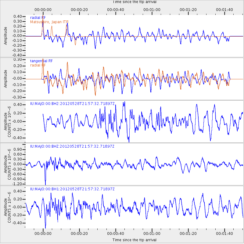
MAJO Matsushiro, Japan - Earthquake Result Viewer
*The percent match for this event was below the threshold and hence no stack was calculated.
| Earthquake location: |
Tonga Islands |
| Earthquake latitude/longitude: |
-20.0/-176.0 |
| Earthquake time(UTC): |
2012/05/28 (149) 21:47:09 GMT |
| Earthquake Depth: |
211 km |
| Earthquake Magnitude: |
5.9 MW, 5.3 MB, 5.9 MW |
| Earthquake Catalog/Contributor: |
WHDF/NEIC |
|
| Network: |
IU Global Seismograph Network (GSN - IRIS/USGS) |
| Station: |
MAJO Matsushiro, Japan |
| Lat/Lon: |
36.55 N/138.20 E |
| Elevation: |
405 m |
|
| Distance: |
70.9 deg |
| Az: |
322.335 deg |
| Baz: |
134.459 deg |
| Ray Param: |
$rayparam |
*The percent match for this event was below the threshold and hence was not used in the summary stack. |
|
| Radial Match: |
61.068764 % |
| Radial Bump: |
400 |
| Transverse Match: |
55.751995 % |
| Transverse Bump: |
400 |
| SOD ConfigId: |
558545 |
| Insert Time: |
2013-09-19 19:19:51.023 +0000 |
| GWidth: |
2.5 |
| Max Bumps: |
400 |
| Tol: |
0.001 |
|
Signal To Noise
| Channel | StoN | STA | LTA |
| IU:MAJO:00:BHZ:20120528T21:57:32.71897Z | 4.9383388 | 3.5716732E-7 | 7.23254E-8 |
| IU:MAJO:00:BH1:20120528T21:57:32.71897Z | 2.6665347 | 2.0077292E-7 | 7.529357E-8 |
| IU:MAJO:00:BH2:20120528T21:57:32.71897Z | 1.3936679 | 1.5253445E-7 | 1.09448195E-7 |
| Arrivals |
| Ps | |
| PpPs | |
| PsPs/PpSs | |


