You are here: Home > Network List > US - United States National Seismic Network Stations List
> Station MNTX Cornudas Mountains, Texas, USA > Earthquake Result Viewer
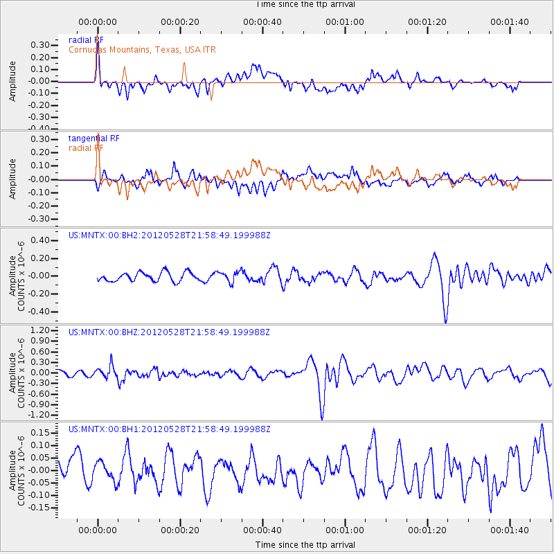
MNTX Cornudas Mountains, Texas, USA - Earthquake Result Viewer
*The percent match for this event was below the threshold and hence no stack was calculated.
| Earthquake location: |
Tonga Islands |
| Earthquake latitude/longitude: |
-20.0/-176.0 |
| Earthquake time(UTC): |
2012/05/28 (149) 21:47:09 GMT |
| Earthquake Depth: |
211 km |
| Earthquake Magnitude: |
5.9 MW, 5.3 MB, 5.9 MW |
| Earthquake Catalog/Contributor: |
WHDF/NEIC |
|
| Network: |
US United States National Seismic Network |
| Station: |
MNTX Cornudas Mountains, Texas, USA |
| Lat/Lon: |
31.70 N/105.38 W |
| Elevation: |
404 m |
|
| Distance: |
84.9 deg |
| Az: |
53.82 deg |
| Baz: |
242.967 deg |
| Ray Param: |
$rayparam |
*The percent match for this event was below the threshold and hence was not used in the summary stack. |
|
| Radial Match: |
62.67173 % |
| Radial Bump: |
400 |
| Transverse Match: |
62.271786 % |
| Transverse Bump: |
400 |
| SOD ConfigId: |
558545 |
| Insert Time: |
2013-09-19 19:20:39.987 +0000 |
| GWidth: |
2.5 |
| Max Bumps: |
400 |
| Tol: |
0.001 |
|
Signal To Noise
| Channel | StoN | STA | LTA |
| US:MNTX:00:BHZ:20120528T21:58:49.199988Z | 2.3441424 | 1.7107764E-7 | 7.298091E-8 |
| US:MNTX:00:BH1:20120528T21:58:49.199988Z | 1.0989697 | 3.777239E-8 | 3.4370732E-8 |
| US:MNTX:00:BH2:20120528T21:58:49.199988Z | 1.2014565 | 6.030524E-8 | 5.019344E-8 |
| Arrivals |
| Ps | |
| PpPs | |
| PsPs/PpSs | |


