You are here: Home > Network List > US - United States National Seismic Network Stations List
> Station HAWA Hanford, Washington, USA > Earthquake Result Viewer
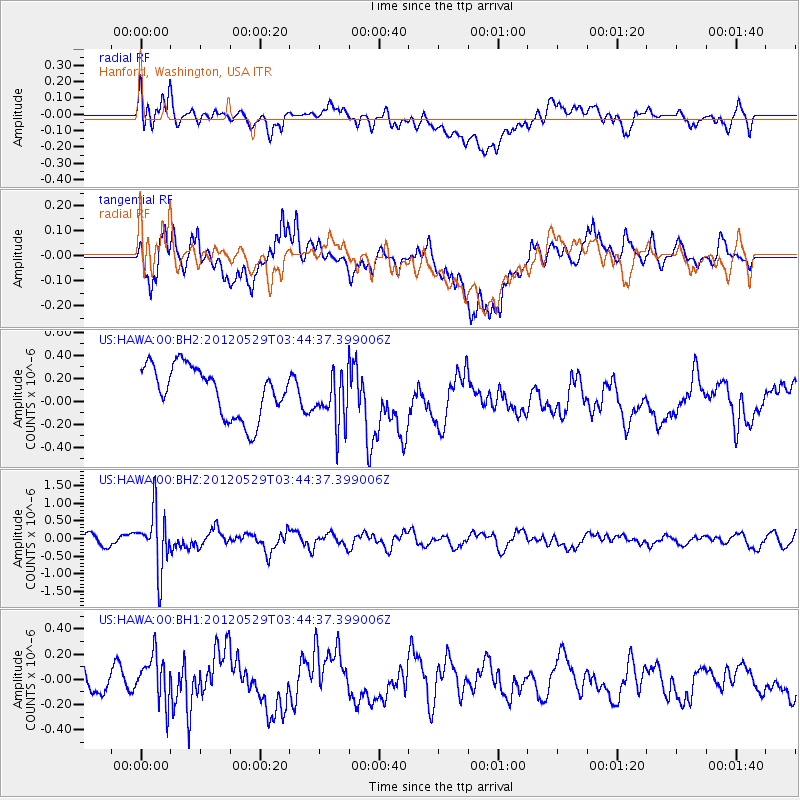
HAWA Hanford, Washington, USA - Earthquake Result Viewer
*The percent match for this event was below the threshold and hence no stack was calculated.
| Earthquake location: |
South Of Fiji Islands |
| Earthquake latitude/longitude: |
-22.1/-179.6 |
| Earthquake time(UTC): |
2012/05/29 (150) 03:33:25 GMT |
| Earthquake Depth: |
602 km |
| Earthquake Magnitude: |
5.6 MB, 5.8 MW, 5.9 MW |
| Earthquake Catalog/Contributor: |
WHDF/NEIC |
|
| Network: |
US United States National Seismic Network |
| Station: |
HAWA Hanford, Washington, USA |
| Lat/Lon: |
46.39 N/119.53 W |
| Elevation: |
364 m |
|
| Distance: |
87.1 deg |
| Az: |
36.914 deg |
| Baz: |
233.573 deg |
| Ray Param: |
$rayparam |
*The percent match for this event was below the threshold and hence was not used in the summary stack. |
|
| Radial Match: |
54.31053 % |
| Radial Bump: |
400 |
| Transverse Match: |
55.078415 % |
| Transverse Bump: |
400 |
| SOD ConfigId: |
558545 |
| Insert Time: |
2013-09-19 19:27:48.237 +0000 |
| GWidth: |
2.5 |
| Max Bumps: |
400 |
| Tol: |
0.001 |
|
Signal To Noise
| Channel | StoN | STA | LTA |
| US:HAWA:00:BHZ:20120529T03:44:37.399006Z | 5.458832 | 8.498688E-7 | 1.5568693E-7 |
| US:HAWA:00:BH1:20120529T03:44:37.399006Z | 1.5675721 | 1.8592576E-7 | 1.1860746E-7 |
| US:HAWA:00:BH2:20120529T03:44:37.399006Z | 1.0528083 | 2.307625E-7 | 2.1918757E-7 |
| Arrivals |
| Ps | |
| PpPs | |
| PsPs/PpSs | |


