You are here: Home > Network List > US - United States National Seismic Network Stations List
> Station WMOK Wichita Mountains, Oklahoma, USA > Earthquake Result Viewer
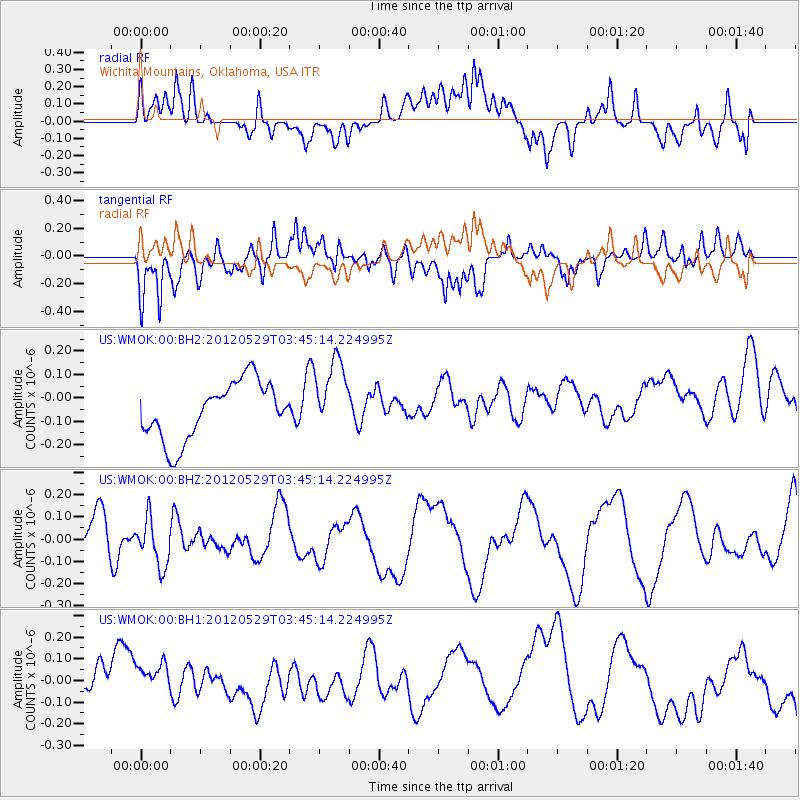
WMOK Wichita Mountains, Oklahoma, USA - Earthquake Result Viewer
*The percent match for this event was below the threshold and hence no stack was calculated.
| Earthquake location: |
South Of Fiji Islands |
| Earthquake latitude/longitude: |
-22.1/-179.6 |
| Earthquake time(UTC): |
2012/05/29 (150) 03:33:25 GMT |
| Earthquake Depth: |
602 km |
| Earthquake Magnitude: |
5.6 MB, 5.8 MW, 5.9 MW |
| Earthquake Catalog/Contributor: |
WHDF/NEIC |
|
| Network: |
US United States National Seismic Network |
| Station: |
WMOK Wichita Mountains, Oklahoma, USA |
| Lat/Lon: |
34.74 N/98.78 W |
| Elevation: |
486 m |
|
| Distance: |
95.2 deg |
| Az: |
54.726 deg |
| Baz: |
246.802 deg |
| Ray Param: |
$rayparam |
*The percent match for this event was below the threshold and hence was not used in the summary stack. |
|
| Radial Match: |
46.083004 % |
| Radial Bump: |
400 |
| Transverse Match: |
64.32469 % |
| Transverse Bump: |
400 |
| SOD ConfigId: |
558545 |
| Insert Time: |
2013-09-19 19:28:14.306 +0000 |
| GWidth: |
2.5 |
| Max Bumps: |
400 |
| Tol: |
0.001 |
|
Signal To Noise
| Channel | StoN | STA | LTA |
| US:WMOK:00:BHZ:20120529T03:45:14.224995Z | 0.9066059 | 1.05851306E-7 | 1.1675559E-7 |
| US:WMOK:00:BH1:20120529T03:45:14.224995Z | 0.8220933 | 1.4283252E-7 | 1.7374246E-7 |
| US:WMOK:00:BH2:20120529T03:45:14.224995Z | 1.3156875 | 1.5993812E-7 | 1.215624E-7 |
| Arrivals |
| Ps | |
| PpPs | |
| PsPs/PpSs | |


