You are here: Home > Network List > CN - Canadian National Seismograph Network Stations List
> Station RES RESOLUTE, N.W.T. > Earthquake Result Viewer
RES RESOLUTE, N.W.T. - Earthquake Result Viewer
| Earthquake location: |
Kuril Islands |
| Earthquake latitude/longitude: |
43.2/146.4 |
| Earthquake time(UTC): |
1997/07/14 (195) 16:09:35 GMT |
| Earthquake Depth: |
33 km |
| Earthquake Magnitude: |
5.9 MB, 5.8 MS, 6.1 UNKNOWN, 5.8 ME |
| Earthquake Catalog/Contributor: |
WHDF/NEIC |
|
| Network: |
CN Canadian National Seismograph Network |
| Station: |
RES RESOLUTE, N.W.T. |
| Lat/Lon: |
74.69 N/94.90 W |
| Elevation: |
15 m |
|
| Distance: |
55.6 deg |
| Az: |
16.405 deg |
| Baz: |
309.054 deg |
| Ray Param: |
0.064624086 |
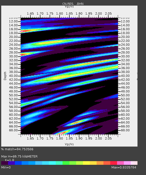
| Estimated Moho Depth: |
69.75 km |
| Estimated Crust Vp/Vs: |
1.80 |
| Assumed Crust Vp: |
6.367 km/s |
| Estimated Crust Vs: |
3.537 km/s |
| Estimated Crust Poisson's Ratio: |
0.28 |
|
| Radial Match: |
94.753586 % |
| Radial Bump: |
377 |
| Transverse Match: |
84.77285 % |
| Transverse Bump: |
400 |
| SOD ConfigId: |
6273 |
| Insert Time: |
2010-02-27 07:01:19.305 +0000 |
| GWidth: |
2.5 |
| Max Bumps: |
400 |
| Tol: |
0.001 |
|

Signal To Noise
| Channel | StoN | STA | LTA |
| CN:RES: :BHN:19970714T16:18:37.299011Z | 8.634742 | 1559.6241 | 180.62198 |
| CN:RES: :BHE:19970714T16:18:37.299011Z | 8.37991 | 1804.8866 | 215.38258 |
| CN:RES: :BHZ:19970714T16:18:37.299011Z | 16.42597 | 5389.4946 | 328.10815 |
| Arrivals |
| Ps | 9.2 SECOND |
| PpPs | 29 SECOND |
| PsPs/PpSs | 38 SECOND |


