You are here: Home > Network List > US - United States National Seismic Network Stations List
> Station AMTX Amarillo, Texas, USA > Earthquake Result Viewer
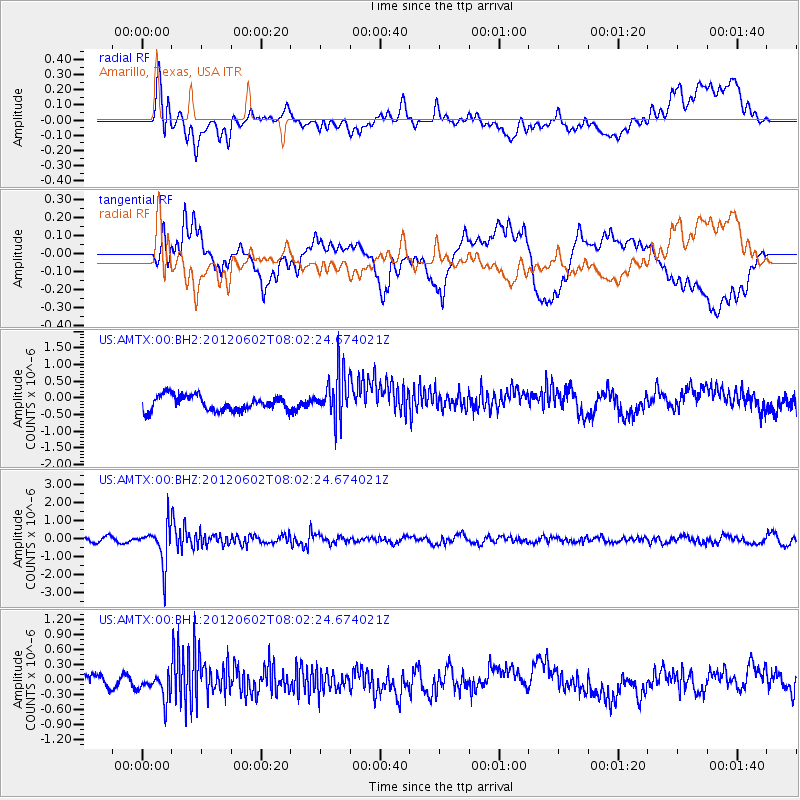
AMTX Amarillo, Texas, USA - Earthquake Result Viewer
*The percent match for this event was below the threshold and hence no stack was calculated.
| Earthquake location: |
Salta Province, Argentina |
| Earthquake latitude/longitude: |
-22.1/-63.6 |
| Earthquake time(UTC): |
2012/06/02 (154) 07:52:53 GMT |
| Earthquake Depth: |
527 km |
| Earthquake Magnitude: |
5.8 MB, 5.9 MW, 6.0 MW |
| Earthquake Catalog/Contributor: |
WHDF/NEIC |
|
| Network: |
US United States National Seismic Network |
| Station: |
AMTX Amarillo, Texas, USA |
| Lat/Lon: |
34.53 N/101.41 W |
| Elevation: |
1010 m |
|
| Distance: |
66.8 deg |
| Az: |
326.549 deg |
| Baz: |
141.73 deg |
| Ray Param: |
$rayparam |
*The percent match for this event was below the threshold and hence was not used in the summary stack. |
|
| Radial Match: |
54.133694 % |
| Radial Bump: |
400 |
| Transverse Match: |
48.94509 % |
| Transverse Bump: |
400 |
| SOD ConfigId: |
558545 |
| Insert Time: |
2013-09-19 19:45:20.000 +0000 |
| GWidth: |
2.5 |
| Max Bumps: |
400 |
| Tol: |
0.001 |
|
Signal To Noise
| Channel | StoN | STA | LTA |
| US:AMTX:00:BHZ:20120602T08:02:24.674021Z | 8.020368 | 1.0852741E-6 | 1.3531476E-7 |
| US:AMTX:00:BH1:20120602T08:02:24.674021Z | 2.0605354 | 2.750444E-7 | 1.33482E-7 |
| US:AMTX:00:BH2:20120602T08:02:24.674021Z | 1.1282766 | 2.5781083E-7 | 2.2849966E-7 |
| Arrivals |
| Ps | |
| PpPs | |
| PsPs/PpSs | |


