You are here: Home > Network List > US - United States National Seismic Network Stations List
> Station DGMT Dagmar, Montana, USA > Earthquake Result Viewer
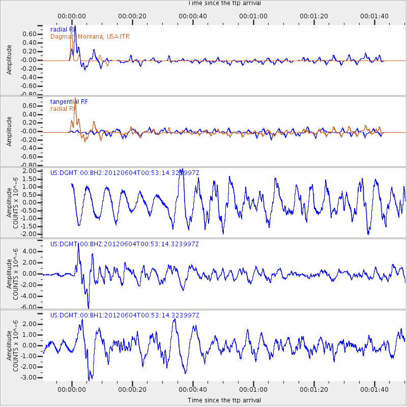
DGMT Dagmar, Montana, USA - Earthquake Result Viewer
*The percent match for this event was below the threshold and hence no stack was calculated.
| Earthquake location: |
South Of Panama |
| Earthquake latitude/longitude: |
5.3/-82.6 |
| Earthquake time(UTC): |
2012/06/04 (156) 00:45:15 GMT |
| Earthquake Depth: |
7.0 km |
| Earthquake Magnitude: |
5.9 MB, 5.9 MS, 6.3 MW, 6.2 MW |
| Earthquake Catalog/Contributor: |
WHDF/NEIC |
|
| Network: |
US United States National Seismic Network |
| Station: |
DGMT Dagmar, Montana, USA |
| Lat/Lon: |
48.47 N/104.20 W |
| Elevation: |
0.0 m |
|
| Distance: |
46.8 deg |
| Az: |
340.385 deg |
| Baz: |
149.847 deg |
| Ray Param: |
$rayparam |
*The percent match for this event was below the threshold and hence was not used in the summary stack. |
|
| Radial Match: |
80.98838 % |
| Radial Bump: |
274 |
| Transverse Match: |
57.183704 % |
| Transverse Bump: |
348 |
| SOD ConfigId: |
558545 |
| Insert Time: |
2013-09-19 19:51:15.237 +0000 |
| GWidth: |
2.5 |
| Max Bumps: |
400 |
| Tol: |
0.001 |
|
Signal To Noise
| Channel | StoN | STA | LTA |
| US:DGMT:00:BHZ:20120604T00:53:14.323997Z | 9.512967 | 2.0757043E-6 | 2.1819736E-7 |
| US:DGMT:00:BH1:20120604T00:53:14.323997Z | 1.8990378 | 1.14255E-6 | 6.016468E-7 |
| US:DGMT:00:BH2:20120604T00:53:14.323997Z | 0.9941816 | 6.973295E-7 | 7.0141056E-7 |
| Arrivals |
| Ps | |
| PpPs | |
| PsPs/PpSs | |


