You are here: Home > Network List > CN - Canadian National Seismograph Network Stations List
> Station RES RESOLUTE, N.W.T. > Earthquake Result Viewer
RES RESOLUTE, N.W.T. - Earthquake Result Viewer
| Earthquake location: |
South Of Mariana Islands |
| Earthquake latitude/longitude: |
10.5/145.7 |
| Earthquake time(UTC): |
2007/09/30 (273) 02:08:30 GMT |
| Earthquake Depth: |
14 km |
| Earthquake Magnitude: |
6.4 MB, 7.1 MS, 6.9 MW, 6.9 MW |
| Earthquake Catalog/Contributor: |
WHDF/NEIC |
|
| Network: |
CN Canadian National Seismograph Network |
| Station: |
RES RESOLUTE, N.W.T. |
| Lat/Lon: |
74.69 N/94.90 W |
| Elevation: |
15 m |
|
| Distance: |
87.4 deg |
| Az: |
13.403 deg |
| Baz: |
300.909 deg |
| Ray Param: |
0.04335272 |
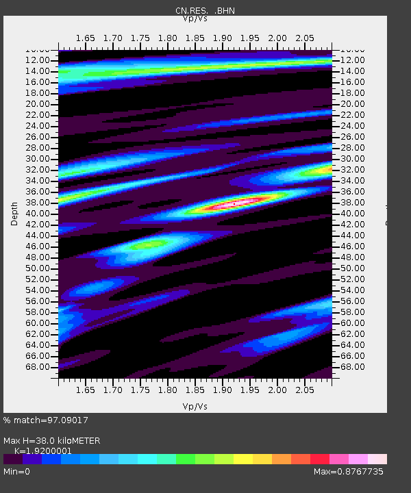
| Estimated Moho Depth: |
38.0 km |
| Estimated Crust Vp/Vs: |
1.92 |
| Assumed Crust Vp: |
6.367 km/s |
| Estimated Crust Vs: |
3.316 km/s |
| Estimated Crust Poisson's Ratio: |
0.31 |
|
| Radial Match: |
97.09017 % |
| Radial Bump: |
308 |
| Transverse Match: |
84.904785 % |
| Transverse Bump: |
400 |
| SOD ConfigId: |
2564 |
| Insert Time: |
2010-02-27 07:02:04.849 +0000 |
| GWidth: |
2.5 |
| Max Bumps: |
400 |
| Tol: |
0.001 |
|
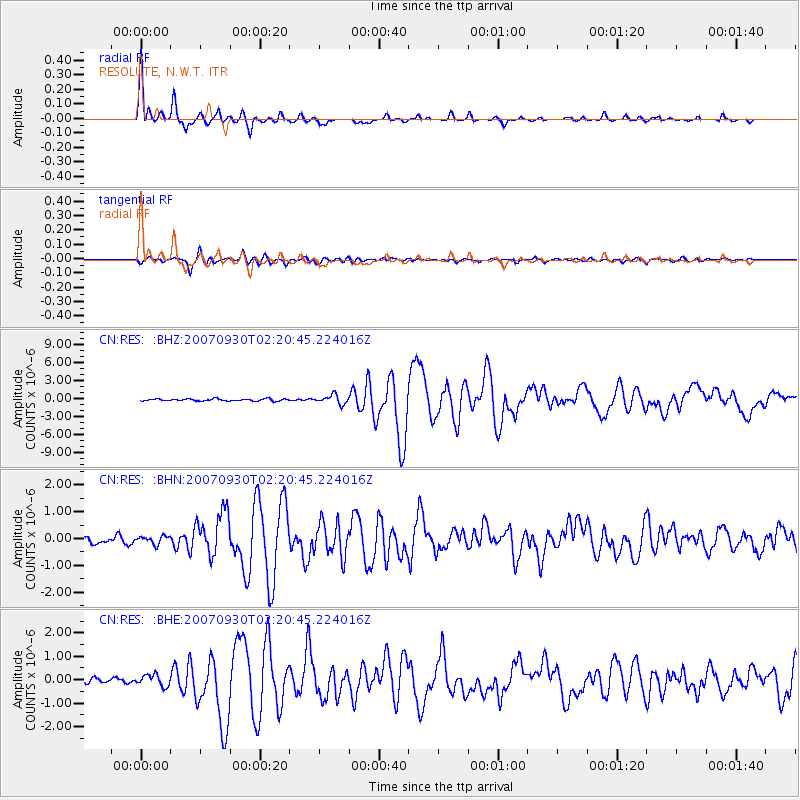
Signal To Noise
| Channel | StoN | STA | LTA |
| CN:RES: :BHN:20070930T02:20:45.224016Z | 1.0524105 | 1.474662E-7 | 1.4012232E-7 |
| CN:RES: :BHE:20070930T02:20:45.224016Z | 1.9058927 | 2.4095797E-7 | 1.2642788E-7 |
| CN:RES: :BHZ:20070930T02:20:45.224016Z | 4.367009 | 7.3262015E-7 | 1.6776244E-7 |
| Arrivals |
| Ps | 5.6 SECOND |
| PpPs | 17 SECOND |
| PsPs/PpSs | 23 SECOND |


