You are here: Home > Network List > YB13 - Continental Dynamics/Cent. Anatolian Tectonics:Surface to Mantle Dynamics During Stations List
> Station AT09 Yukariulupinar,Malatya,Turkey > Earthquake Result Viewer
AT09 Yukariulupinar,Malatya,Turkey - Earthquake Result Viewer
| Earthquake location: |
Iceland |
| Earthquake latitude/longitude: |
64.6/-17.4 |
| Earthquake time(UTC): |
2014/09/15 (258) 08:05:02 GMT |
| Earthquake Depth: |
10 km |
| Earthquake Magnitude: |
5.5 MWW, 5.5 MWC |
| Earthquake Catalog/Contributor: |
NEIC PDE/NEIC COMCAT |
|
| Network: |
YB Continental Dynamics/Cent. Anatolian Tectonics:Surface to Mantle Dynamics During |
| Station: |
AT09 Yukariulupinar,Malatya,Turkey |
| Lat/Lon: |
38.40 N/37.57 E |
| Elevation: |
1429 m |
|
| Distance: |
41.2 deg |
| Az: |
102.253 deg |
| Baz: |
327.512 deg |
| Ray Param: |
0.07396014 |
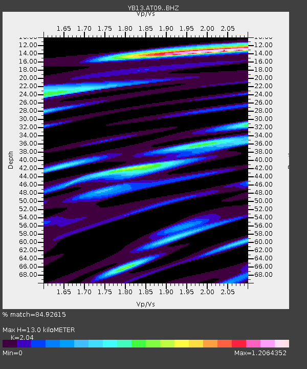
| Estimated Moho Depth: |
13.0 km |
| Estimated Crust Vp/Vs: |
2.04 |
| Assumed Crust Vp: |
6.35 km/s |
| Estimated Crust Vs: |
3.113 km/s |
| Estimated Crust Poisson's Ratio: |
0.34 |
|
| Radial Match: |
84.92615 % |
| Radial Bump: |
400 |
| Transverse Match: |
68.838776 % |
| Transverse Bump: |
400 |
| SOD ConfigId: |
3390531 |
| Insert Time: |
2019-04-14 01:40:27.341 +0000 |
| GWidth: |
2.5 |
| Max Bumps: |
400 |
| Tol: |
0.001 |
|

Signal To Noise
| Channel | StoN | STA | LTA |
| YB:AT09: :BHZ:20140915T08:12:15.619001Z | 8.400251 | 3.820779E-7 | 4.5484104E-8 |
| YB:AT09: :BHN:20140915T08:12:15.619001Z | 5.4446564 | 2.0425725E-7 | 3.751518E-8 |
| YB:AT09: :BHE:20140915T08:12:15.619001Z | 7.973669 | 2.7301803E-7 | 3.423995E-8 |
| Arrivals |
| Ps | 2.3 SECOND |
| PpPs | 5.9 SECOND |
| PsPs/PpSs | 8.1 SECOND |


