You are here: Home > Network List > IU - Global Seismograph Network (GSN - IRIS/USGS) Stations List
> Station HNR Honiara, Solomon Islands > Earthquake Result Viewer
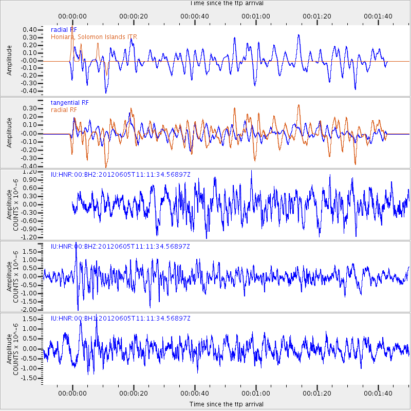
HNR Honiara, Solomon Islands - Earthquake Result Viewer
*The percent match for this event was below the threshold and hence no stack was calculated.
| Earthquake location: |
Northern Sumatra, Indonesia |
| Earthquake latitude/longitude: |
5.5/94.7 |
| Earthquake time(UTC): |
2012/06/05 (157) 11:01:20 GMT |
| Earthquake Depth: |
54 km |
| Earthquake Magnitude: |
5.6 MB, 5.3 MW |
| Earthquake Catalog/Contributor: |
WHDF/NEIC |
|
| Network: |
IU Global Seismograph Network (GSN - IRIS/USGS) |
| Station: |
HNR Honiara, Solomon Islands |
| Lat/Lon: |
9.44 S/159.95 E |
| Elevation: |
100 m |
|
| Distance: |
66.7 deg |
| Az: |
102.663 deg |
| Baz: |
280.125 deg |
| Ray Param: |
$rayparam |
*The percent match for this event was below the threshold and hence was not used in the summary stack. |
|
| Radial Match: |
58.693974 % |
| Radial Bump: |
400 |
| Transverse Match: |
54.254253 % |
| Transverse Bump: |
400 |
| SOD ConfigId: |
558545 |
| Insert Time: |
2013-09-19 20:00:24.943 +0000 |
| GWidth: |
2.5 |
| Max Bumps: |
400 |
| Tol: |
0.001 |
|
Signal To Noise
| Channel | StoN | STA | LTA |
| IU:HNR:00:BHZ:20120605T11:11:34.56897Z | 2.6236665 | 8.183497E-7 | 3.1191072E-7 |
| IU:HNR:00:BH1:20120605T11:11:34.56897Z | 2.1816583 | 6.208953E-7 | 2.8459786E-7 |
| IU:HNR:00:BH2:20120605T11:11:34.56897Z | 1.6031408 | 3.9000736E-7 | 2.4327704E-7 |
| Arrivals |
| Ps | |
| PpPs | |
| PsPs/PpSs | |


