You are here: Home > Network List > US - United States National Seismic Network Stations List
> Station ERPA Erie, Pennsylvania, USA > Earthquake Result Viewer
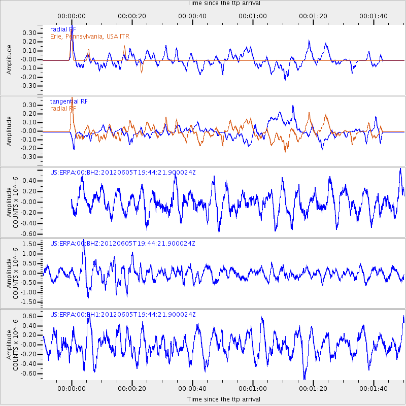
ERPA Erie, Pennsylvania, USA - Earthquake Result Viewer
*The percent match for this event was below the threshold and hence no stack was calculated.
| Earthquake location: |
Off East Coast Of Honshu, Japan |
| Earthquake latitude/longitude: |
34.9/141.1 |
| Earthquake time(UTC): |
2012/06/05 (157) 19:31:33 GMT |
| Earthquake Depth: |
15 km |
| Earthquake Magnitude: |
6.2 MB, 6.0 MS, 6.1 MW, 6.1 MW |
| Earthquake Catalog/Contributor: |
WHDF/NEIC |
|
| Network: |
US United States National Seismic Network |
| Station: |
ERPA Erie, Pennsylvania, USA |
| Lat/Lon: |
42.12 N/79.99 W |
| Elevation: |
306 m |
|
| Distance: |
94.6 deg |
| Az: |
29.397 deg |
| Baz: |
327.181 deg |
| Ray Param: |
$rayparam |
*The percent match for this event was below the threshold and hence was not used in the summary stack. |
|
| Radial Match: |
62.41732 % |
| Radial Bump: |
400 |
| Transverse Match: |
54.839622 % |
| Transverse Bump: |
400 |
| SOD ConfigId: |
558545 |
| Insert Time: |
2013-09-19 20:04:21.801 +0000 |
| GWidth: |
2.5 |
| Max Bumps: |
400 |
| Tol: |
0.001 |
|
Signal To Noise
| Channel | StoN | STA | LTA |
| US:ERPA:00:BHZ:20120605T19:44:21.900024Z | 2.7659197 | 6.066687E-7 | 2.1933708E-7 |
| US:ERPA:00:BH1:20120605T19:44:21.900024Z | 0.916797 | 2.0531317E-7 | 2.2394616E-7 |
| US:ERPA:00:BH2:20120605T19:44:21.900024Z | 1.1500813 | 2.109352E-7 | 1.8340894E-7 |
| Arrivals |
| Ps | |
| PpPs | |
| PsPs/PpSs | |


