You are here: Home > Network List > US - United States National Seismic Network Stations List
> Station EGMT Eagleton, Montana, USA > Earthquake Result Viewer
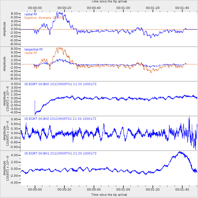
EGMT Eagleton, Montana, USA - Earthquake Result Viewer
*The percent match for this event was below the threshold and hence no stack was calculated.
| Earthquake location: |
Taiwan Region |
| Earthquake latitude/longitude: |
22.4/121.4 |
| Earthquake time(UTC): |
2012/06/06 (158) 01:08:35 GMT |
| Earthquake Depth: |
24 km |
| Earthquake Magnitude: |
5.6 MW, 5.5 MW, 5.6 MB |
| Earthquake Catalog/Contributor: |
NEIC PDE/NEIC PDE-M |
|
| Network: |
US United States National Seismic Network |
| Station: |
EGMT Eagleton, Montana, USA |
| Lat/Lon: |
48.02 N/109.75 W |
| Elevation: |
1055 m |
|
| Distance: |
96.3 deg |
| Az: |
31.748 deg |
| Baz: |
313.48 deg |
| Ray Param: |
$rayparam |
*The percent match for this event was below the threshold and hence was not used in the summary stack. |
|
| Radial Match: |
59.615734 % |
| Radial Bump: |
400 |
| Transverse Match: |
59.32854 % |
| Transverse Bump: |
400 |
| SOD ConfigId: |
558545 |
| Insert Time: |
2013-09-19 20:08:16.445 +0000 |
| GWidth: |
2.5 |
| Max Bumps: |
400 |
| Tol: |
0.001 |
|
Signal To Noise
| Channel | StoN | STA | LTA |
| US:EGMT:00:BHZ:20120606T01:21:30.100017Z | 0.9882193 | 1.6653847E-7 | 1.685238E-7 |
| US:EGMT:00:BH1:20120606T01:21:30.100017Z | 0.6657624 | 1.9990225E-6 | 3.0026063E-6 |
| US:EGMT:00:BH2:20120606T01:21:30.100017Z | 0.7356632 | 1.100367E-6 | 1.4957484E-6 |
| Arrivals |
| Ps | |
| PpPs | |
| PsPs/PpSs | |


