You are here: Home > Network List > IU - Global Seismograph Network (GSN - IRIS/USGS) Stations List
> Station RSSD Black Hills, South Dakota, USA > Earthquake Result Viewer
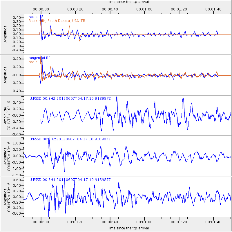
RSSD Black Hills, South Dakota, USA - Earthquake Result Viewer
*The percent match for this event was below the threshold and hence no stack was calculated.
| Earthquake location: |
Chile-Argentina Border Region |
| Earthquake latitude/longitude: |
-36.1/-70.6 |
| Earthquake time(UTC): |
2012/06/07 (159) 04:05:04 GMT |
| Earthquake Depth: |
8.0 km |
| Earthquake Magnitude: |
6.0 MW, 5.7 MS, 5.9 MB, 5.9 MW |
| Earthquake Catalog/Contributor: |
NEIC PDE/NEIC PDE-M |
|
| Network: |
IU Global Seismograph Network (GSN - IRIS/USGS) |
| Station: |
RSSD Black Hills, South Dakota, USA |
| Lat/Lon: |
44.12 N/104.04 W |
| Elevation: |
2090 m |
|
| Distance: |
85.4 deg |
| Az: |
336.52 deg |
| Baz: |
153.373 deg |
| Ray Param: |
$rayparam |
*The percent match for this event was below the threshold and hence was not used in the summary stack. |
|
| Radial Match: |
79.97129 % |
| Radial Bump: |
400 |
| Transverse Match: |
71.80863 % |
| Transverse Bump: |
400 |
| SOD ConfigId: |
558545 |
| Insert Time: |
2013-09-19 20:10:05.686 +0000 |
| GWidth: |
2.5 |
| Max Bumps: |
400 |
| Tol: |
0.001 |
|
Signal To Noise
| Channel | StoN | STA | LTA |
| IU:RSSD:00:BHZ:20120607T04:17:10.918987Z | 4.964162 | 5.1849906E-7 | 1.0444846E-7 |
| IU:RSSD:00:BH1:20120607T04:17:10.918987Z | 3.5449107 | 2.51652E-7 | 7.0989664E-8 |
| IU:RSSD:00:BH2:20120607T04:17:10.918987Z | 1.0442108 | 1.2158398E-7 | 1.1643623E-7 |
| Arrivals |
| Ps | |
| PpPs | |
| PsPs/PpSs | |


