You are here: Home > Network List > US - United States National Seismic Network Stations List
> Station ERPA Erie, Pennsylvania, USA > Earthquake Result Viewer
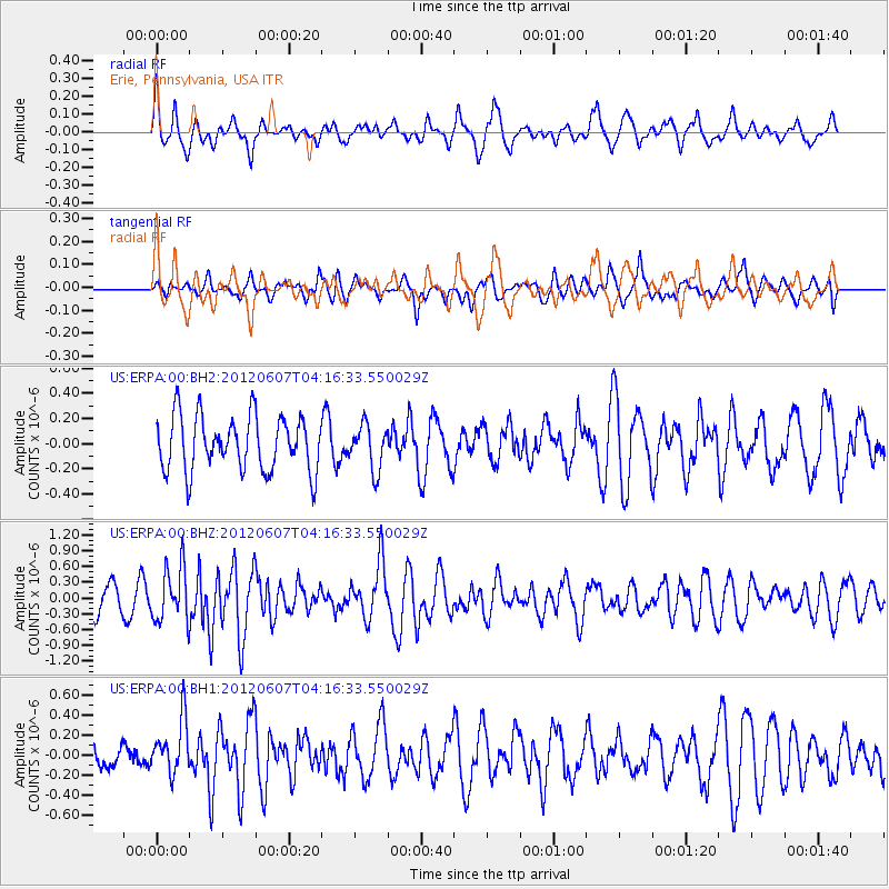
ERPA Erie, Pennsylvania, USA - Earthquake Result Viewer
*The percent match for this event was below the threshold and hence no stack was calculated.
| Earthquake location: |
Chile-Argentina Border Region |
| Earthquake latitude/longitude: |
-36.1/-70.6 |
| Earthquake time(UTC): |
2012/06/07 (159) 04:05:04 GMT |
| Earthquake Depth: |
8.0 km |
| Earthquake Magnitude: |
6.0 MW, 5.7 MS, 5.9 MB, 5.9 MW |
| Earthquake Catalog/Contributor: |
NEIC PDE/NEIC PDE-M |
|
| Network: |
US United States National Seismic Network |
| Station: |
ERPA Erie, Pennsylvania, USA |
| Lat/Lon: |
42.12 N/79.99 W |
| Elevation: |
306 m |
|
| Distance: |
78.3 deg |
| Az: |
352.857 deg |
| Baz: |
172.218 deg |
| Ray Param: |
$rayparam |
*The percent match for this event was below the threshold and hence was not used in the summary stack. |
|
| Radial Match: |
73.18182 % |
| Radial Bump: |
400 |
| Transverse Match: |
47.22559 % |
| Transverse Bump: |
397 |
| SOD ConfigId: |
558545 |
| Insert Time: |
2013-09-19 20:11:08.514 +0000 |
| GWidth: |
2.5 |
| Max Bumps: |
400 |
| Tol: |
0.001 |
|
Signal To Noise
| Channel | StoN | STA | LTA |
| US:ERPA:00:BHZ:20120607T04:16:33.550029Z | 2.4316711 | 5.1493106E-7 | 2.1176015E-7 |
| US:ERPA:00:BH1:20120607T04:16:33.550029Z | 1.9570404 | 2.73945E-7 | 1.3997922E-7 |
| US:ERPA:00:BH2:20120607T04:16:33.550029Z | 0.80838495 | 1.7516534E-7 | 2.1668555E-7 |
| Arrivals |
| Ps | |
| PpPs | |
| PsPs/PpSs | |


