You are here: Home > Network List > II - Global Seismograph Network (GSN - IRIS/IDA) Stations List
> Station WRAB Tennant Creek, NT, Australia > Earthquake Result Viewer
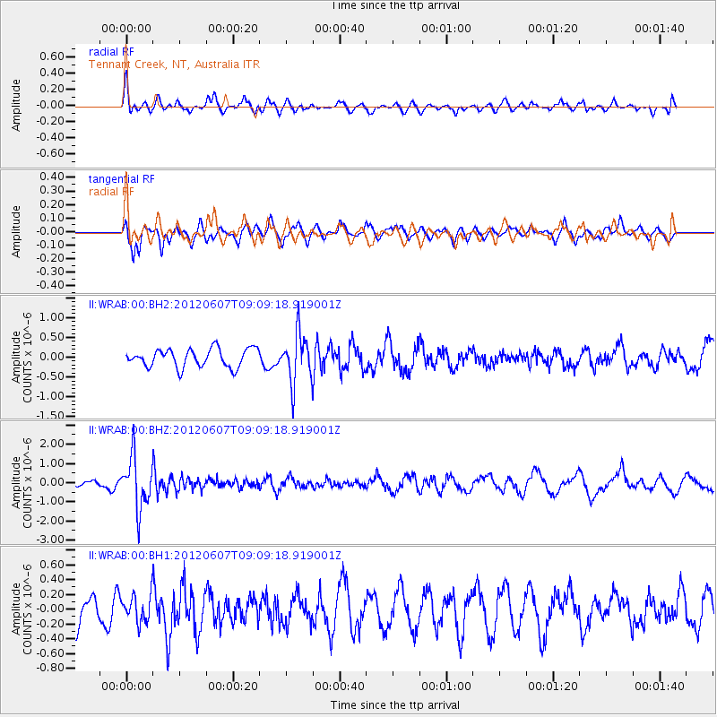
WRAB Tennant Creek, NT, Australia - Earthquake Result Viewer
*The percent match for this event was below the threshold and hence no stack was calculated.
| Earthquake location: |
Fiji Islands Region |
| Earthquake latitude/longitude: |
-20.2/-176.3 |
| Earthquake time(UTC): |
2012/06/07 (159) 09:01:51 GMT |
| Earthquake Depth: |
266 km |
| Earthquake Magnitude: |
5.8 MW, 5.6 MB, 5.9 MW |
| Earthquake Catalog/Contributor: |
NEIC PDE/NEIC PDE-M |
|
| Network: |
II Global Seismograph Network (GSN - IRIS/IDA) |
| Station: |
WRAB Tennant Creek, NT, Australia |
| Lat/Lon: |
19.93 S/134.36 E |
| Elevation: |
366 m |
|
| Distance: |
46.2 deg |
| Az: |
261.404 deg |
| Baz: |
99.192 deg |
| Ray Param: |
$rayparam |
*The percent match for this event was below the threshold and hence was not used in the summary stack. |
|
| Radial Match: |
66.200165 % |
| Radial Bump: |
400 |
| Transverse Match: |
65.45058 % |
| Transverse Bump: |
400 |
| SOD ConfigId: |
558545 |
| Insert Time: |
2013-09-19 20:13:21.062 +0000 |
| GWidth: |
2.5 |
| Max Bumps: |
400 |
| Tol: |
0.001 |
|
Signal To Noise
| Channel | StoN | STA | LTA |
| II:WRAB:00:BHZ:20120607T09:09:18.919001Z | 6.430328 | 1.3303578E-6 | 2.0688802E-7 |
| II:WRAB:00:BH1:20120607T09:09:18.919001Z | 0.8476311 | 1.9036986E-7 | 2.2459047E-7 |
| II:WRAB:00:BH2:20120607T09:09:18.919001Z | 2.7015486 | 6.1758277E-7 | 2.2860324E-7 |
| Arrivals |
| Ps | |
| PpPs | |
| PsPs/PpSs | |


