You are here: Home > Network List > IU - Global Seismograph Network (GSN - IRIS/USGS) Stations List
> Station MAJO Matsushiro, Japan > Earthquake Result Viewer
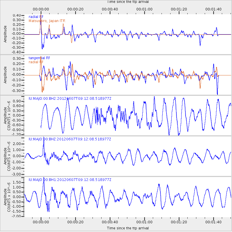
MAJO Matsushiro, Japan - Earthquake Result Viewer
*The percent match for this event was below the threshold and hence no stack was calculated.
| Earthquake location: |
Fiji Islands Region |
| Earthquake latitude/longitude: |
-20.2/-176.3 |
| Earthquake time(UTC): |
2012/06/07 (159) 09:01:51 GMT |
| Earthquake Depth: |
266 km |
| Earthquake Magnitude: |
5.8 MW, 5.6 MB, 5.9 MW |
| Earthquake Catalog/Contributor: |
NEIC PDE/NEIC PDE-M |
|
| Network: |
IU Global Seismograph Network (GSN - IRIS/USGS) |
| Station: |
MAJO Matsushiro, Japan |
| Lat/Lon: |
36.55 N/138.20 E |
| Elevation: |
405 m |
|
| Distance: |
70.9 deg |
| Az: |
322.601 deg |
| Baz: |
134.893 deg |
| Ray Param: |
$rayparam |
*The percent match for this event was below the threshold and hence was not used in the summary stack. |
|
| Radial Match: |
55.896763 % |
| Radial Bump: |
400 |
| Transverse Match: |
46.934677 % |
| Transverse Bump: |
400 |
| SOD ConfigId: |
558545 |
| Insert Time: |
2013-09-19 20:13:44.703 +0000 |
| GWidth: |
2.5 |
| Max Bumps: |
400 |
| Tol: |
0.001 |
|
Signal To Noise
| Channel | StoN | STA | LTA |
| IU:MAJO:00:BHZ:20120607T09:12:08.518977Z | 2.029764 | 9.62654E-7 | 4.7426894E-7 |
| IU:MAJO:00:BH1:20120607T09:12:08.518977Z | 2.5393763 | 9.270704E-7 | 3.65078E-7 |
| IU:MAJO:00:BH2:20120607T09:12:08.518977Z | 0.66952246 | 3.7643062E-7 | 5.6223746E-7 |
| Arrivals |
| Ps | |
| PpPs | |
| PsPs/PpSs | |


