You are here: Home > Network List > US - United States National Seismic Network Stations List
> Station MNTX Cornudas Mountains, Texas, USA > Earthquake Result Viewer
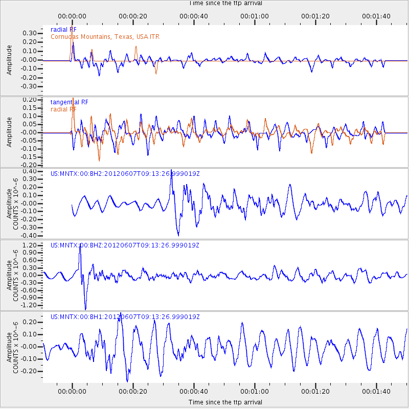
MNTX Cornudas Mountains, Texas, USA - Earthquake Result Viewer
*The percent match for this event was below the threshold and hence no stack was calculated.
| Earthquake location: |
Fiji Islands Region |
| Earthquake latitude/longitude: |
-20.2/-176.3 |
| Earthquake time(UTC): |
2012/06/07 (159) 09:01:51 GMT |
| Earthquake Depth: |
266 km |
| Earthquake Magnitude: |
5.8 MW, 5.6 MB, 5.9 MW |
| Earthquake Catalog/Contributor: |
NEIC PDE/NEIC PDE-M |
|
| Network: |
US United States National Seismic Network |
| Station: |
MNTX Cornudas Mountains, Texas, USA |
| Lat/Lon: |
31.70 N/105.38 W |
| Elevation: |
404 m |
|
| Distance: |
85.3 deg |
| Az: |
53.946 deg |
| Baz: |
242.983 deg |
| Ray Param: |
$rayparam |
*The percent match for this event was below the threshold and hence was not used in the summary stack. |
|
| Radial Match: |
67.65783 % |
| Radial Bump: |
354 |
| Transverse Match: |
79.02092 % |
| Transverse Bump: |
400 |
| SOD ConfigId: |
558545 |
| Insert Time: |
2013-09-19 20:14:46.362 +0000 |
| GWidth: |
2.5 |
| Max Bumps: |
400 |
| Tol: |
0.001 |
|
Signal To Noise
| Channel | StoN | STA | LTA |
| US:MNTX:00:BHZ:20120607T09:13:26.999019Z | 4.3688784 | 5.852733E-7 | 1.339642E-7 |
| US:MNTX:00:BH1:20120607T09:13:26.999019Z | 1.2301774 | 6.246735E-8 | 5.077914E-8 |
| US:MNTX:00:BH2:20120607T09:13:26.999019Z | 3.2411215 | 1.788219E-7 | 5.5172848E-8 |
| Arrivals |
| Ps | |
| PpPs | |
| PsPs/PpSs | |


