You are here: Home > Network List > II - Global Seismograph Network (GSN - IRIS/IDA) Stations List
> Station CMLA Cha de Macela, Sao Miguel Island, Azores > Earthquake Result Viewer
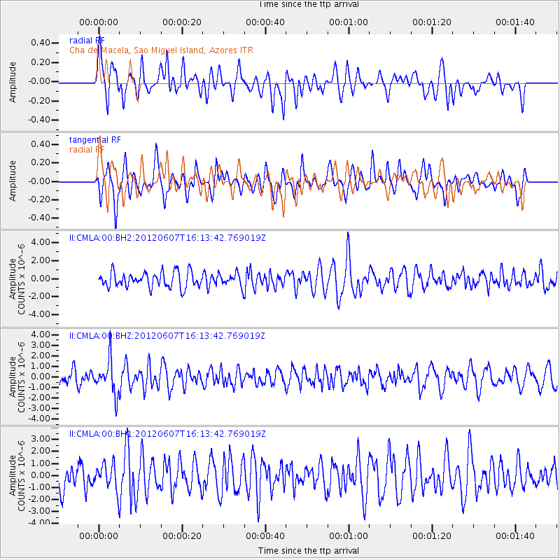
CMLA Cha de Macela, Sao Miguel Island, Azores - Earthquake Result Viewer
*The percent match for this event was below the threshold and hence no stack was calculated.
| Earthquake location: |
Southern Peru |
| Earthquake latitude/longitude: |
-15.9/-72.4 |
| Earthquake time(UTC): |
2012/06/07 (159) 16:03:18 GMT |
| Earthquake Depth: |
110 km |
| Earthquake Magnitude: |
6.1 MW, 6.1 MB, 6.1 MW |
| Earthquake Catalog/Contributor: |
NEIC PDE/NEIC PDE-M |
|
| Network: |
II Global Seismograph Network (GSN - IRIS/IDA) |
| Station: |
CMLA Cha de Macela, Sao Miguel Island, Azores |
| Lat/Lon: |
37.76 N/25.52 W |
| Elevation: |
429 m |
|
| Distance: |
69.2 deg |
| Az: |
38.242 deg |
| Baz: |
228.73 deg |
| Ray Param: |
$rayparam |
*The percent match for this event was below the threshold and hence was not used in the summary stack. |
|
| Radial Match: |
55.317978 % |
| Radial Bump: |
400 |
| Transverse Match: |
69.83917 % |
| Transverse Bump: |
400 |
| SOD ConfigId: |
558545 |
| Insert Time: |
2013-09-19 20:16:01.530 +0000 |
| GWidth: |
2.5 |
| Max Bumps: |
400 |
| Tol: |
0.001 |
|
Signal To Noise
| Channel | StoN | STA | LTA |
| II:CMLA:00:BHZ:20120607T16:13:42.769019Z | 2.5854552 | 1.661938E-6 | 6.428029E-7 |
| II:CMLA:00:BH1:20120607T16:13:42.769019Z | 0.8222739 | 1.0887566E-6 | 1.3240801E-6 |
| II:CMLA:00:BH2:20120607T16:13:42.769019Z | 0.85119367 | 7.2123794E-7 | 8.4732534E-7 |
| Arrivals |
| Ps | |
| PpPs | |
| PsPs/PpSs | |


