You are here: Home > Network List > US - United States National Seismic Network Stations List
> Station AMTX Amarillo, Texas, USA > Earthquake Result Viewer
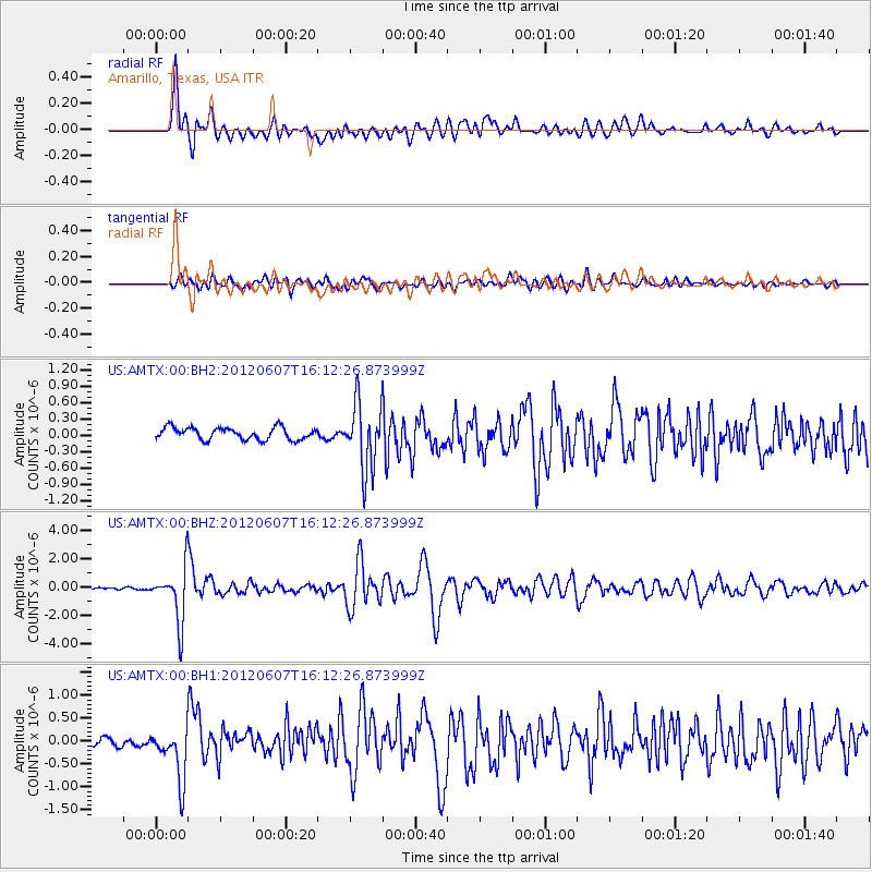
AMTX Amarillo, Texas, USA - Earthquake Result Viewer
*The percent match for this event was below the threshold and hence no stack was calculated.
| Earthquake location: |
Southern Peru |
| Earthquake latitude/longitude: |
-15.9/-72.4 |
| Earthquake time(UTC): |
2012/06/07 (159) 16:03:18 GMT |
| Earthquake Depth: |
110 km |
| Earthquake Magnitude: |
6.1 MW, 6.1 MB, 6.1 MW |
| Earthquake Catalog/Contributor: |
NEIC PDE/NEIC PDE-M |
|
| Network: |
US United States National Seismic Network |
| Station: |
AMTX Amarillo, Texas, USA |
| Lat/Lon: |
34.53 N/101.41 W |
| Elevation: |
1010 m |
|
| Distance: |
57.2 deg |
| Az: |
331.573 deg |
| Baz: |
146.298 deg |
| Ray Param: |
$rayparam |
*The percent match for this event was below the threshold and hence was not used in the summary stack. |
|
| Radial Match: |
85.96008 % |
| Radial Bump: |
400 |
| Transverse Match: |
73.48708 % |
| Transverse Bump: |
400 |
| SOD ConfigId: |
558545 |
| Insert Time: |
2013-09-19 20:17:06.089 +0000 |
| GWidth: |
2.5 |
| Max Bumps: |
400 |
| Tol: |
0.001 |
|
Signal To Noise
| Channel | StoN | STA | LTA |
| US:AMTX:00:BHZ:20120607T16:12:26.873999Z | 15.548185 | 1.8692675E-6 | 1.2022416E-7 |
| US:AMTX:00:BH1:20120607T16:12:26.873999Z | 6.7666645 | 5.747753E-7 | 8.4942194E-8 |
| US:AMTX:00:BH2:20120607T16:12:26.873999Z | 3.429228 | 3.8947996E-7 | 1.1357657E-7 |
| Arrivals |
| Ps | |
| PpPs | |
| PsPs/PpSs | |


