You are here: Home > Network List > US - United States National Seismic Network Stations List
> Station CBKS Cedar Bluff, Kansas, USA > Earthquake Result Viewer
CBKS Cedar Bluff, Kansas, USA - Earthquake Result Viewer
| Earthquake location: |
Southern Peru |
| Earthquake latitude/longitude: |
-15.9/-72.4 |
| Earthquake time(UTC): |
2012/06/07 (159) 16:03:18 GMT |
| Earthquake Depth: |
110 km |
| Earthquake Magnitude: |
6.1 MW, 6.1 MB, 6.1 MW |
| Earthquake Catalog/Contributor: |
NEIC PDE/NEIC PDE-M |
|
| Network: |
US United States National Seismic Network |
| Station: |
CBKS Cedar Bluff, Kansas, USA |
| Lat/Lon: |
38.81 N/99.74 W |
| Elevation: |
677 m |
|
| Distance: |
60.1 deg |
| Az: |
335.569 deg |
| Baz: |
149.372 deg |
| Ray Param: |
0.061421342 |
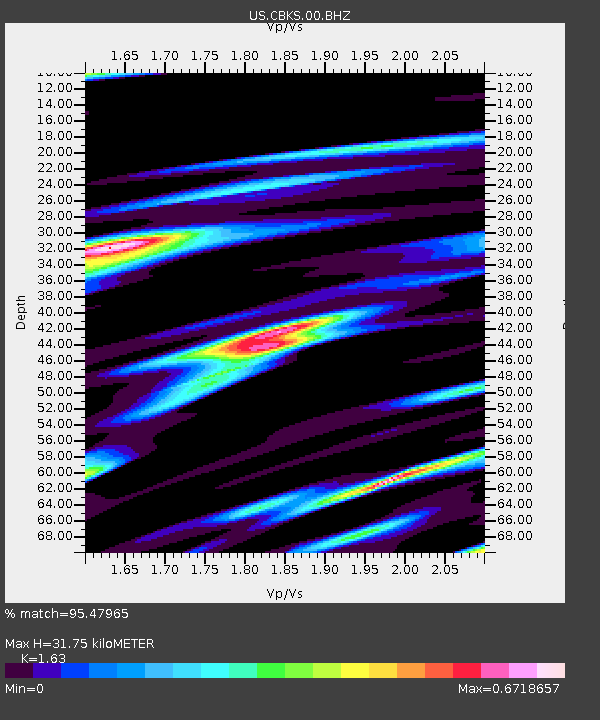
| Estimated Moho Depth: |
31.75 km |
| Estimated Crust Vp/Vs: |
1.63 |
| Assumed Crust Vp: |
6.483 km/s |
| Estimated Crust Vs: |
3.977 km/s |
| Estimated Crust Poisson's Ratio: |
0.20 |
|
| Radial Match: |
95.47965 % |
| Radial Bump: |
251 |
| Transverse Match: |
84.10074 % |
| Transverse Bump: |
400 |
| SOD ConfigId: |
558545 |
| Insert Time: |
2013-09-19 20:17:21.412 +0000 |
| GWidth: |
2.5 |
| Max Bumps: |
400 |
| Tol: |
0.001 |
|
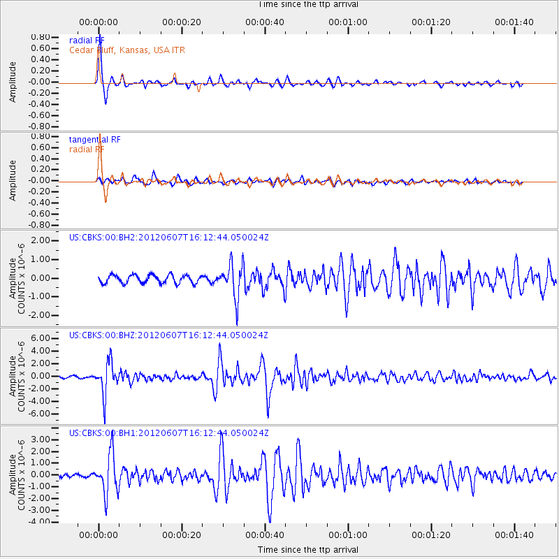
Signal To Noise
| Channel | StoN | STA | LTA |
| US:CBKS:00:BHZ:20120607T16:12:44.050024Z | 14.84606 | 2.604905E-6 | 1.7546104E-7 |
| US:CBKS:00:BH1:20120607T16:12:44.050024Z | 8.235329 | 1.743037E-6 | 2.116536E-7 |
| US:CBKS:00:BH2:20120607T16:12:44.050024Z | 4.265265 | 9.3739476E-7 | 2.1977411E-7 |
| Arrivals |
| Ps | 3.2 SECOND |
| PpPs | 12 SECOND |
| PsPs/PpSs | 15 SECOND |


