You are here: Home > Network List > US - United States National Seismic Network Stations List
> Station ECSD EROS Data Center, Sioux Falls, South Dakota, USA > Earthquake Result Viewer
ECSD EROS Data Center, Sioux Falls, South Dakota, USA - Earthquake Result Viewer
| Earthquake location: |
Southern Peru |
| Earthquake latitude/longitude: |
-15.9/-72.4 |
| Earthquake time(UTC): |
2012/06/07 (159) 16:03:18 GMT |
| Earthquake Depth: |
110 km |
| Earthquake Magnitude: |
6.1 MW, 6.1 MB, 6.1 MW |
| Earthquake Catalog/Contributor: |
NEIC PDE/NEIC PDE-M |
|
| Network: |
US United States National Seismic Network |
| Station: |
ECSD EROS Data Center, Sioux Falls, South Dakota, USA |
| Lat/Lon: |
43.73 N/96.61 W |
| Elevation: |
478 m |
|
| Distance: |
63.3 deg |
| Az: |
340.576 deg |
| Baz: |
153.8 deg |
| Ray Param: |
0.059348553 |
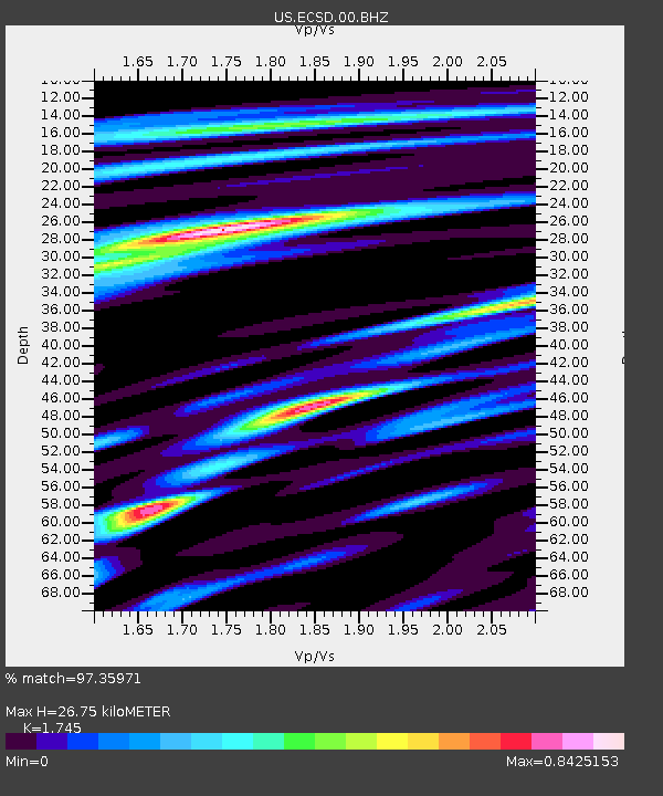
| Estimated Moho Depth: |
26.75 km |
| Estimated Crust Vp/Vs: |
1.75 |
| Assumed Crust Vp: |
6.498 km/s |
| Estimated Crust Vs: |
3.724 km/s |
| Estimated Crust Poisson's Ratio: |
0.26 |
|
| Radial Match: |
97.35971 % |
| Radial Bump: |
376 |
| Transverse Match: |
85.220436 % |
| Transverse Bump: |
400 |
| SOD ConfigId: |
558545 |
| Insert Time: |
2013-09-19 20:17:37.428 +0000 |
| GWidth: |
2.5 |
| Max Bumps: |
400 |
| Tol: |
0.001 |
|

Signal To Noise
| Channel | StoN | STA | LTA |
| US:ECSD:00:BHZ:20120607T16:13:05.475012Z | 12.87443 | 2.5718305E-6 | 1.9976265E-7 |
| US:ECSD:00:BH1:20120607T16:13:05.475012Z | 7.8648624 | 7.030789E-7 | 8.939494E-8 |
| US:ECSD:00:BH2:20120607T16:13:05.475012Z | 10.2204275 | 1.3015836E-6 | 1.273512E-7 |
| Arrivals |
| Ps | 3.2 SECOND |
| PpPs | 11 SECOND |
| PsPs/PpSs | 14 SECOND |


