You are here: Home > Network List > US - United States National Seismic Network Stations List
> Station KSU1 Kansas State University--Konza Prairie, Kansas, USA > Earthquake Result Viewer
KSU1 Kansas State University--Konza Prairie, Kansas, USA - Earthquake Result Viewer
| Earthquake location: |
Southern Peru |
| Earthquake latitude/longitude: |
-15.9/-72.4 |
| Earthquake time(UTC): |
2012/06/07 (159) 16:03:18 GMT |
| Earthquake Depth: |
110 km |
| Earthquake Magnitude: |
6.1 MW, 6.1 MB, 6.1 MW |
| Earthquake Catalog/Contributor: |
NEIC PDE/NEIC PDE-M |
|
| Network: |
US United States National Seismic Network |
| Station: |
KSU1 Kansas State University--Konza Prairie, Kansas, USA |
| Lat/Lon: |
39.10 N/96.61 W |
| Elevation: |
347 m |
|
| Distance: |
59.2 deg |
| Az: |
338.202 deg |
| Baz: |
152.661 deg |
| Ray Param: |
0.062028263 |
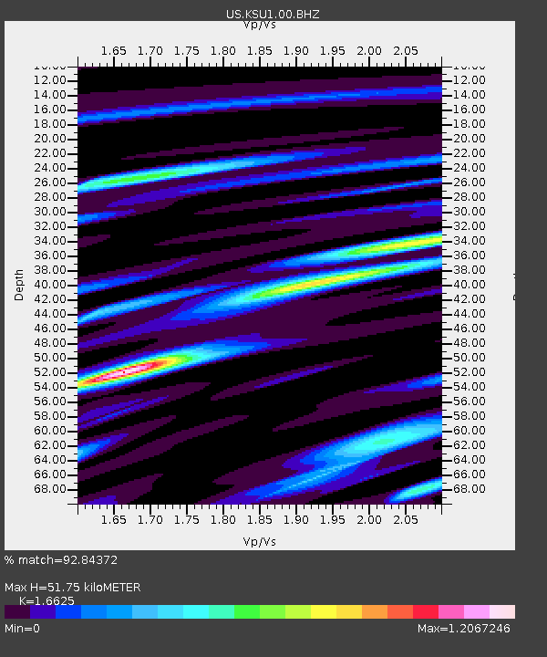
| Estimated Moho Depth: |
51.75 km |
| Estimated Crust Vp/Vs: |
1.66 |
| Assumed Crust Vp: |
6.483 km/s |
| Estimated Crust Vs: |
3.899 km/s |
| Estimated Crust Poisson's Ratio: |
0.22 |
|
| Radial Match: |
92.84372 % |
| Radial Bump: |
400 |
| Transverse Match: |
77.53409 % |
| Transverse Bump: |
400 |
| SOD ConfigId: |
558545 |
| Insert Time: |
2013-09-19 20:18:08.488 +0000 |
| GWidth: |
2.5 |
| Max Bumps: |
400 |
| Tol: |
0.001 |
|

Signal To Noise
| Channel | StoN | STA | LTA |
| US:KSU1:00:BHZ:20120607T16:12:37.675024Z | 13.84911 | 2.0567113E-6 | 1.4850858E-7 |
| US:KSU1:00:BH1:20120607T16:12:37.675024Z | 8.269378 | 1.1713348E-6 | 1.4164729E-7 |
| US:KSU1:00:BH2:20120607T16:12:37.675024Z | 0.9331353 | 1.5618583E-7 | 1.673775E-7 |
| Arrivals |
| Ps | 5.6 SECOND |
| PpPs | 20 SECOND |
| PsPs/PpSs | 26 SECOND |


