You are here: Home > Network List > II - Global Seismograph Network (GSN - IRIS/IDA) Stations List
> Station KAPI Kappang, Sulawesi, Indonesia > Earthquake Result Viewer
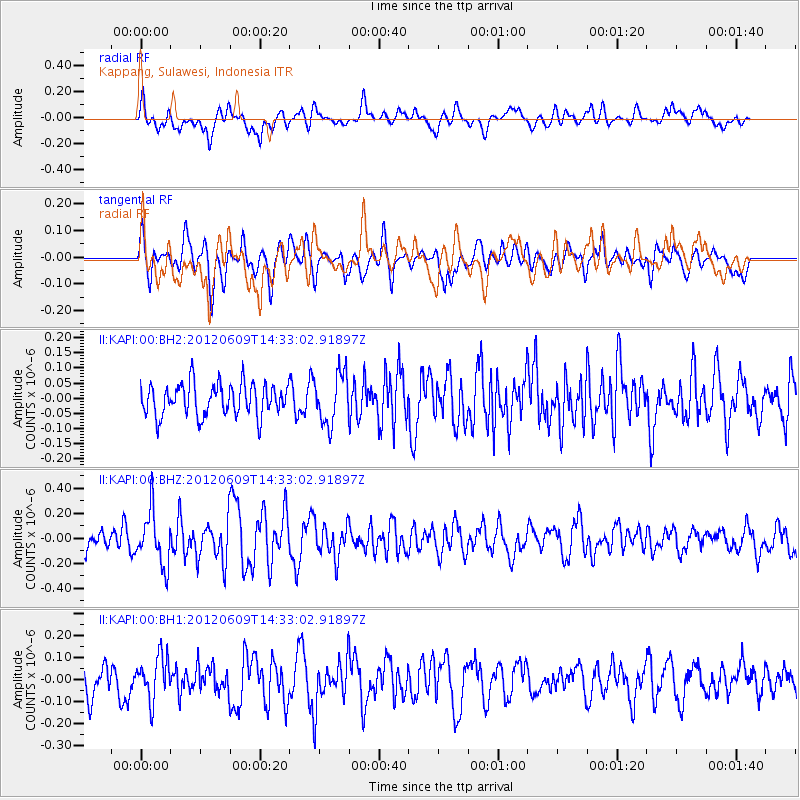
KAPI Kappang, Sulawesi, Indonesia - Earthquake Result Viewer
*The percent match for this event was below the threshold and hence no stack was calculated.
| Earthquake location: |
Kuril Islands |
| Earthquake latitude/longitude: |
48.9/154.9 |
| Earthquake time(UTC): |
2012/06/09 (161) 14:23:20 GMT |
| Earthquake Depth: |
49 km |
| Earthquake Magnitude: |
5.5 MW |
| Earthquake Catalog/Contributor: |
NEIC PDE/NEIC PDE-M |
|
| Network: |
II Global Seismograph Network (GSN - IRIS/IDA) |
| Station: |
KAPI Kappang, Sulawesi, Indonesia |
| Lat/Lon: |
5.01 S/119.75 E |
| Elevation: |
300 m |
|
| Distance: |
61.8 deg |
| Az: |
220.56 deg |
| Baz: |
25.539 deg |
| Ray Param: |
$rayparam |
*The percent match for this event was below the threshold and hence was not used in the summary stack. |
|
| Radial Match: |
67.64963 % |
| Radial Bump: |
400 |
| Transverse Match: |
65.20907 % |
| Transverse Bump: |
400 |
| SOD ConfigId: |
558545 |
| Insert Time: |
2013-09-19 20:20:18.300 +0000 |
| GWidth: |
2.5 |
| Max Bumps: |
400 |
| Tol: |
0.001 |
|
Signal To Noise
| Channel | StoN | STA | LTA |
| II:KAPI:00:BHZ:20120609T14:33:02.91897Z | 3.8155048 | 2.1351451E-7 | 5.5959703E-8 |
| II:KAPI:00:BH1:20120609T14:33:02.91897Z | 1.8228989 | 9.7611995E-8 | 5.3547677E-8 |
| II:KAPI:00:BH2:20120609T14:33:02.91897Z | 1.575408 | 8.299321E-8 | 5.2680456E-8 |
| Arrivals |
| Ps | |
| PpPs | |
| PsPs/PpSs | |


