You are here: Home > Network List > US - United States National Seismic Network Stations List
> Station AMTX Amarillo, Texas, USA > Earthquake Result Viewer
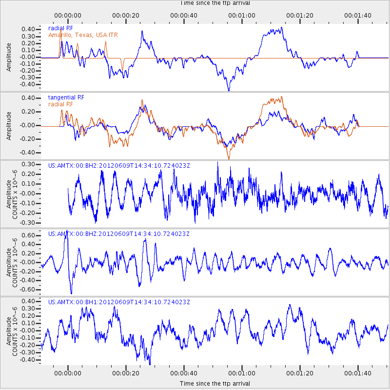
AMTX Amarillo, Texas, USA - Earthquake Result Viewer
*The percent match for this event was below the threshold and hence no stack was calculated.
| Earthquake location: |
Kuril Islands |
| Earthquake latitude/longitude: |
48.9/154.9 |
| Earthquake time(UTC): |
2012/06/09 (161) 14:23:20 GMT |
| Earthquake Depth: |
49 km |
| Earthquake Magnitude: |
5.5 MW |
| Earthquake Catalog/Contributor: |
NEIC PDE/NEIC PDE-M |
|
| Network: |
US United States National Seismic Network |
| Station: |
AMTX Amarillo, Texas, USA |
| Lat/Lon: |
34.53 N/101.41 W |
| Elevation: |
1010 m |
|
| Distance: |
72.9 deg |
| Az: |
57.044 deg |
| Baz: |
317.831 deg |
| Ray Param: |
$rayparam |
*The percent match for this event was below the threshold and hence was not used in the summary stack. |
|
| Radial Match: |
38.83771 % |
| Radial Bump: |
400 |
| Transverse Match: |
31.13147 % |
| Transverse Bump: |
400 |
| SOD ConfigId: |
558545 |
| Insert Time: |
2013-09-19 20:21:48.302 +0000 |
| GWidth: |
2.5 |
| Max Bumps: |
400 |
| Tol: |
0.001 |
|
Signal To Noise
| Channel | StoN | STA | LTA |
| US:AMTX:00:BHZ:20120609T14:34:10.724023Z | 5.129917 | 3.8305583E-7 | 7.467096E-8 |
| US:AMTX:00:BH1:20120609T14:34:10.724023Z | 0.43352687 | 1.3798609E-7 | 3.1828728E-7 |
| US:AMTX:00:BH2:20120609T14:34:10.724023Z | 1.2729636 | 1.5808381E-7 | 1.2418565E-7 |
| Arrivals |
| Ps | |
| PpPs | |
| PsPs/PpSs | |


