You are here: Home > Network List > II - Global Seismograph Network (GSN - IRIS/IDA) Stations List
> Station WRAB Tennant Creek, NT, Australia > Earthquake Result Viewer
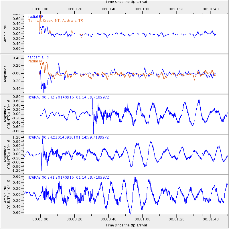
WRAB Tennant Creek, NT, Australia - Earthquake Result Viewer
*The percent match for this event was below the threshold and hence no stack was calculated.
| Earthquake location: |
Fiji Islands Region |
| Earthquake latitude/longitude: |
-21.0/-178.9 |
| Earthquake time(UTC): |
2014/09/16 (259) 01:08:18 GMT |
| Earthquake Depth: |
618 km |
| Earthquake Magnitude: |
5.3 MW |
| Earthquake Catalog/Contributor: |
ISC/ISC |
|
| Network: |
II Global Seismograph Network (GSN - IRIS/IDA) |
| Station: |
WRAB Tennant Creek, NT, Australia |
| Lat/Lon: |
19.93 S/134.36 E |
| Elevation: |
366 m |
|
| Distance: |
43.7 deg |
| Az: |
262.763 deg |
| Baz: |
99.855 deg |
| Ray Param: |
$rayparam |
*The percent match for this event was below the threshold and hence was not used in the summary stack. |
|
| Radial Match: |
61.873093 % |
| Radial Bump: |
400 |
| Transverse Match: |
68.01 % |
| Transverse Bump: |
400 |
| SOD ConfigId: |
3390531 |
| Insert Time: |
2019-04-14 01:48:35.759 +0000 |
| GWidth: |
2.5 |
| Max Bumps: |
400 |
| Tol: |
0.001 |
|
Signal To Noise
| Channel | StoN | STA | LTA |
| II:WRAB:00:BHZ:20140916T01:14:59.718997Z | 2.6584532 | 4.545471E-7 | 1.7098179E-7 |
| II:WRAB:00:BH1:20140916T01:14:59.718997Z | 0.8290034 | 1.2198832E-7 | 1.4715056E-7 |
| II:WRAB:00:BH2:20140916T01:14:59.718997Z | 2.3621469 | 3.1129667E-7 | 1.3178548E-7 |
| Arrivals |
| Ps | |
| PpPs | |
| PsPs/PpSs | |


