You are here: Home > Network List > US - United States National Seismic Network Stations List
> Station DGMT Dagmar, Montana, USA > Earthquake Result Viewer
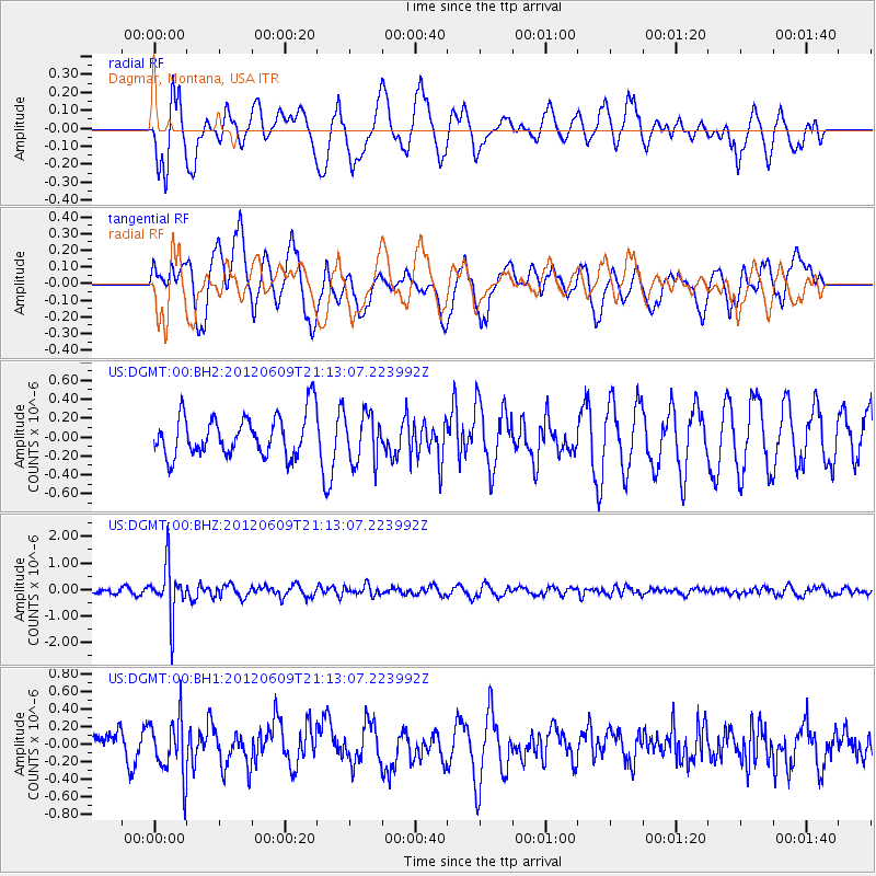
DGMT Dagmar, Montana, USA - Earthquake Result Viewer
*The percent match for this event was below the threshold and hence no stack was calculated.
| Earthquake location: |
Taiwan Region |
| Earthquake latitude/longitude: |
24.6/122.2 |
| Earthquake time(UTC): |
2012/06/09 (161) 21:00:18 GMT |
| Earthquake Depth: |
70 km |
| Earthquake Magnitude: |
5.9 MW, 5.9 MW, 6.0 MB |
| Earthquake Catalog/Contributor: |
NEIC PDE/NEIC PDE-M |
|
| Network: |
US United States National Seismic Network |
| Station: |
DGMT Dagmar, Montana, USA |
| Lat/Lon: |
48.47 N/104.20 W |
| Elevation: |
0.0 m |
|
| Distance: |
96.3 deg |
| Az: |
29.024 deg |
| Baz: |
318.412 deg |
| Ray Param: |
$rayparam |
*The percent match for this event was below the threshold and hence was not used in the summary stack. |
|
| Radial Match: |
49.47104 % |
| Radial Bump: |
400 |
| Transverse Match: |
61.426888 % |
| Transverse Bump: |
400 |
| SOD ConfigId: |
558545 |
| Insert Time: |
2013-09-19 20:25:57.604 +0000 |
| GWidth: |
2.5 |
| Max Bumps: |
400 |
| Tol: |
0.001 |
|
Signal To Noise
| Channel | StoN | STA | LTA |
| US:DGMT:00:BHZ:20120609T21:13:07.223992Z | 7.588389 | 9.602685E-7 | 1.2654445E-7 |
| US:DGMT:00:BH1:20120609T21:13:07.223992Z | 1.2268449 | 3.303876E-7 | 2.6929857E-7 |
| US:DGMT:00:BH2:20120609T21:13:07.223992Z | 1.2090374 | 2.6298505E-7 | 2.1751606E-7 |
| Arrivals |
| Ps | |
| PpPs | |
| PsPs/PpSs | |


