You are here: Home > Network List > US - United States National Seismic Network Stations List
> Station MSO Missoula, Montana, USA > Earthquake Result Viewer
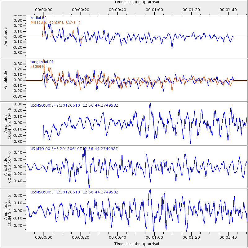
MSO Missoula, Montana, USA - Earthquake Result Viewer
*The percent match for this event was below the threshold and hence no stack was calculated.
| Earthquake location: |
Dodecanese Islands, Greece |
| Earthquake latitude/longitude: |
36.4/28.9 |
| Earthquake time(UTC): |
2012/06/10 (162) 12:44:16 GMT |
| Earthquake Depth: |
35 km |
| Earthquake Magnitude: |
6.0 MW, 5.8 MB, 5.8 MW, 5.9 MS |
| Earthquake Catalog/Contributor: |
NEIC PDE/NEIC PDE-M |
|
| Network: |
US United States National Seismic Network |
| Station: |
MSO Missoula, Montana, USA |
| Lat/Lon: |
46.83 N/113.94 W |
| Elevation: |
1264 m |
|
| Distance: |
90.7 deg |
| Az: |
335.483 deg |
| Baz: |
29.174 deg |
| Ray Param: |
$rayparam |
*The percent match for this event was below the threshold and hence was not used in the summary stack. |
|
| Radial Match: |
61.175297 % |
| Radial Bump: |
400 |
| Transverse Match: |
58.844673 % |
| Transverse Bump: |
400 |
| SOD ConfigId: |
558545 |
| Insert Time: |
2013-09-19 20:28:56.514 +0000 |
| GWidth: |
2.5 |
| Max Bumps: |
400 |
| Tol: |
0.001 |
|
Signal To Noise
| Channel | StoN | STA | LTA |
| US:MSO:00:BHZ:20120610T12:56:44.274998Z | 1.2415895 | 1.0540898E-7 | 8.489841E-8 |
| US:MSO:00:BH1:20120610T12:56:44.274998Z | 1.1031977 | 4.4906354E-8 | 4.070563E-8 |
| US:MSO:00:BH2:20120610T12:56:44.274998Z | 1.3197676 | 1.1945166E-7 | 9.050961E-8 |
| Arrivals |
| Ps | |
| PpPs | |
| PsPs/PpSs | |


