You are here: Home > Network List > US - United States National Seismic Network Stations List
> Station MSO Missoula, Montana, USA > Earthquake Result Viewer
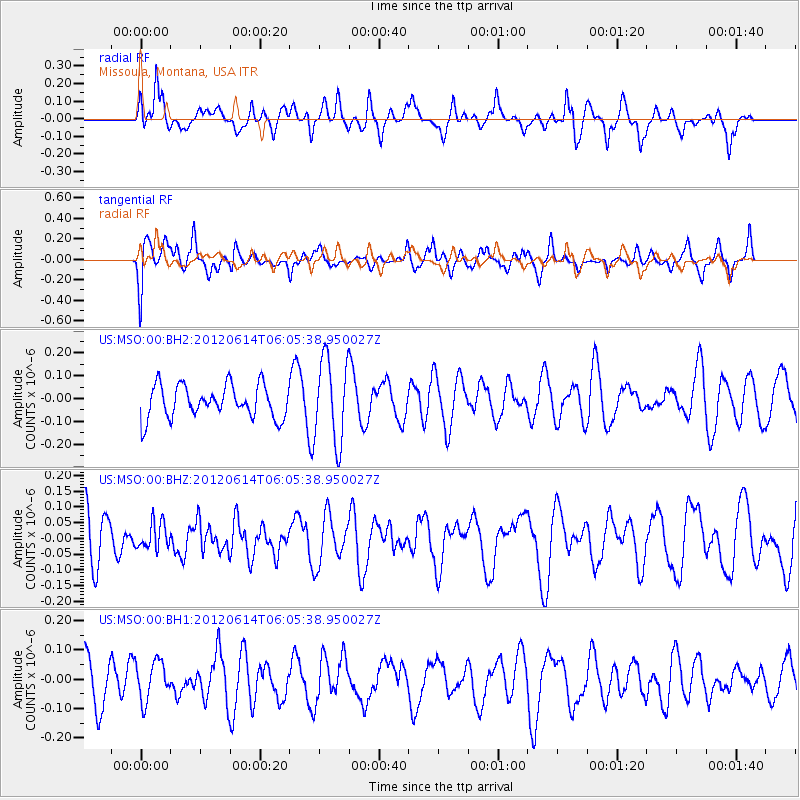
MSO Missoula, Montana, USA - Earthquake Result Viewer
*The percent match for this event was below the threshold and hence no stack was calculated.
| Earthquake location: |
Turkey |
| Earthquake latitude/longitude: |
37.3/42.3 |
| Earthquake time(UTC): |
2012/06/14 (166) 05:52:53 GMT |
| Earthquake Depth: |
5.4 km |
| Earthquake Magnitude: |
5.5 ML, 5.5 ML |
| Earthquake Catalog/Contributor: |
NEIC PDE/NEIC PDE-M |
|
| Network: |
US United States National Seismic Network |
| Station: |
MSO Missoula, Montana, USA |
| Lat/Lon: |
46.83 N/113.94 W |
| Elevation: |
1264 m |
|
| Distance: |
93.6 deg |
| Az: |
343.924 deg |
| Baz: |
18.761 deg |
| Ray Param: |
$rayparam |
*The percent match for this event was below the threshold and hence was not used in the summary stack. |
|
| Radial Match: |
55.90062 % |
| Radial Bump: |
400 |
| Transverse Match: |
54.915863 % |
| Transverse Bump: |
400 |
| SOD ConfigId: |
558545 |
| Insert Time: |
2013-09-19 20:36:12.148 +0000 |
| GWidth: |
2.5 |
| Max Bumps: |
400 |
| Tol: |
0.001 |
|
Signal To Noise
| Channel | StoN | STA | LTA |
| US:MSO:00:BHZ:20120614T06:05:38.950027Z | 0.4097223 | 4.2464563E-8 | 1.036423E-7 |
| US:MSO:00:BH1:20120614T06:05:38.950027Z | 0.8283996 | 6.667487E-8 | 8.0486366E-8 |
| US:MSO:00:BH2:20120614T06:05:38.950027Z | 2.5998054 | 1.8540474E-7 | 7.131486E-8 |
| Arrivals |
| Ps | |
| PpPs | |
| PsPs/PpSs | |


