You are here: Home > Network List > IU - Global Seismograph Network (GSN - IRIS/USGS) Stations List
> Station GNI Garni, Armenia > Earthquake Result Viewer
GNI Garni, Armenia - Earthquake Result Viewer
| Earthquake location: |
Luzon, Philippines |
| Earthquake latitude/longitude: |
15.6/119.6 |
| Earthquake time(UTC): |
2012/06/16 (168) 22:18:47 GMT |
| Earthquake Depth: |
28 km |
| Earthquake Magnitude: |
5.9 MW, 5.7 MS, 5.9 MW, 6.1 MB |
| Earthquake Catalog/Contributor: |
NEIC PDE/NEIC PDE-M |
|
| Network: |
IU Global Seismograph Network (GSN - IRIS/USGS) |
| Station: |
GNI Garni, Armenia |
| Lat/Lon: |
40.15 N/44.74 E |
| Elevation: |
1609 m |
|
| Distance: |
68.6 deg |
| Az: |
307.385 deg |
| Baz: |
87.37 deg |
| Ray Param: |
0.056161977 |
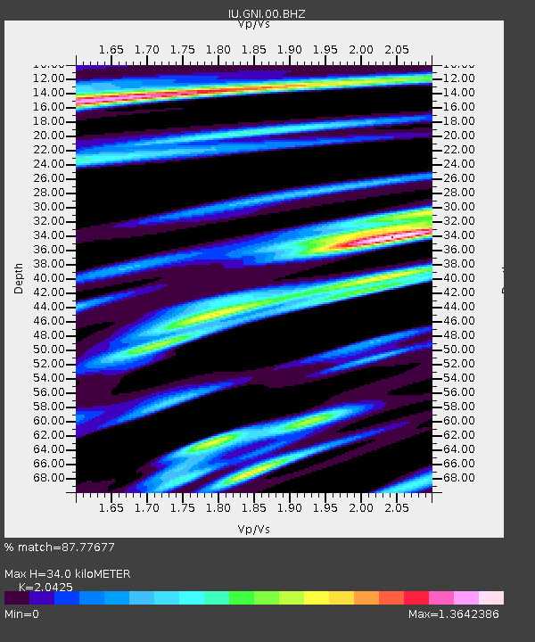
| Estimated Moho Depth: |
34.0 km |
| Estimated Crust Vp/Vs: |
2.04 |
| Assumed Crust Vp: |
6.291 km/s |
| Estimated Crust Vs: |
3.08 km/s |
| Estimated Crust Poisson's Ratio: |
0.34 |
|
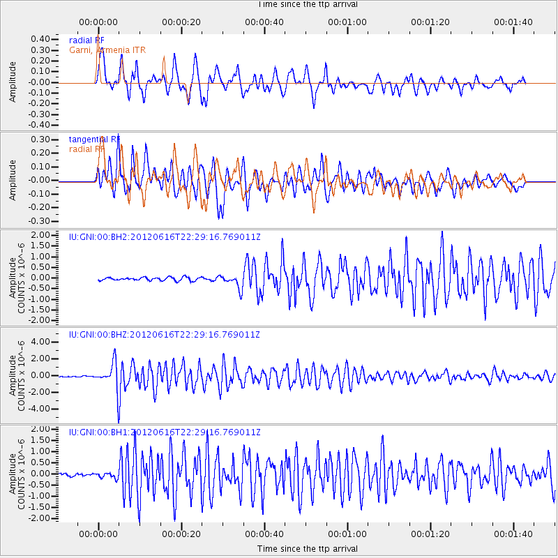
| Radial Match: |
87.77677 % |
| Radial Bump: |
400 |
| Transverse Match: |
80.56503 % |
| Transverse Bump: |
400 |
| SOD ConfigId: |
558545 |
| Insert Time: |
2013-09-19 20:41:25.251 +0000 |
| GWidth: |
2.5 |
| Max Bumps: |
400 |
| Tol: |
0.001 |
|
Signal To Noise
| Channel | StoN | STA | LTA |
| IU:GNI:00:BHZ:20120616T22:29:16.769011Z | 23.913282 | 1.692003E-6 | 7.075578E-8 |
| IU:GNI:00:BH1:20120616T22:29:16.769011Z | 1.4059113 | 1.1979031E-7 | 8.5204746E-8 |
| IU:GNI:00:BH2:20120616T22:29:16.769011Z | 4.4232726 | 3.3373598E-7 | 7.545001E-8 |
| Arrivals |
| Ps | 5.8 SECOND |
| PpPs | 16 SECOND |
| PsPs/PpSs | 22 SECOND |


