You are here: Home > Network List > US - United States National Seismic Network Stations List
> Station RLMT Red Lodge, Montana, USA > Earthquake Result Viewer
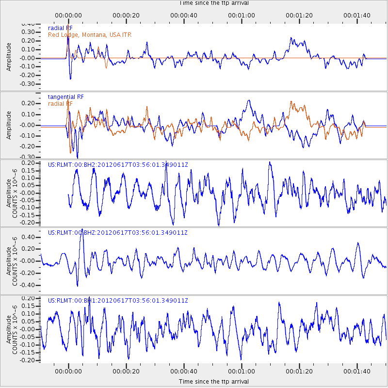
RLMT Red Lodge, Montana, USA - Earthquake Result Viewer
*The percent match for this event was below the threshold and hence no stack was calculated.
| Earthquake location: |
Solomon Islands |
| Earthquake latitude/longitude: |
-8.5/160.4 |
| Earthquake time(UTC): |
2012/06/17 (169) 03:43:10 GMT |
| Earthquake Depth: |
51 km |
| Earthquake Magnitude: |
5.7 MW, 5.6 MW, 6.0 MB |
| Earthquake Catalog/Contributor: |
NEIC PDE/NEIC PDE-M |
|
| Network: |
US United States National Seismic Network |
| Station: |
RLMT Red Lodge, Montana, USA |
| Lat/Lon: |
45.12 N/109.27 W |
| Elevation: |
2086 m |
|
| Distance: |
96.2 deg |
| Az: |
45.411 deg |
| Baz: |
264.256 deg |
| Ray Param: |
$rayparam |
*The percent match for this event was below the threshold and hence was not used in the summary stack. |
|
| Radial Match: |
54.010365 % |
| Radial Bump: |
400 |
| Transverse Match: |
45.52448 % |
| Transverse Bump: |
400 |
| SOD ConfigId: |
558545 |
| Insert Time: |
2013-09-19 20:44:29.763 +0000 |
| GWidth: |
2.5 |
| Max Bumps: |
400 |
| Tol: |
0.001 |
|
Signal To Noise
| Channel | StoN | STA | LTA |
| US:RLMT:00:BHZ:20120617T03:56:01.349011Z | 3.0025165 | 2.4533938E-7 | 8.171125E-8 |
| US:RLMT:00:BH1:20120617T03:56:01.349011Z | 1.1168896 | 8.683187E-8 | 7.774436E-8 |
| US:RLMT:00:BH2:20120617T03:56:01.349011Z | 1.1032243 | 8.8989346E-8 | 8.066297E-8 |
| Arrivals |
| Ps | |
| PpPs | |
| PsPs/PpSs | |


