You are here: Home > Network List > US - United States National Seismic Network Stations List
> Station WUAZ Wupatki, Arizona, USA > Earthquake Result Viewer
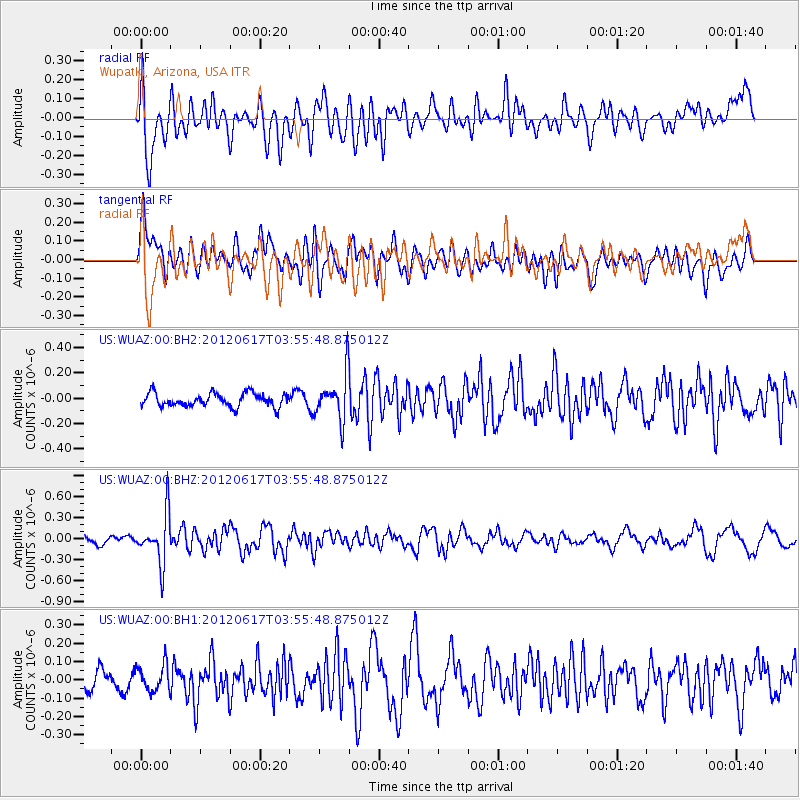
WUAZ Wupatki, Arizona, USA - Earthquake Result Viewer
*The percent match for this event was below the threshold and hence no stack was calculated.
| Earthquake location: |
Solomon Islands |
| Earthquake latitude/longitude: |
-8.5/160.4 |
| Earthquake time(UTC): |
2012/06/17 (169) 03:43:10 GMT |
| Earthquake Depth: |
51 km |
| Earthquake Magnitude: |
5.7 MW, 5.6 MW, 6.0 MB |
| Earthquake Catalog/Contributor: |
NEIC PDE/NEIC PDE-M |
|
| Network: |
US United States National Seismic Network |
| Station: |
WUAZ Wupatki, Arizona, USA |
| Lat/Lon: |
35.52 N/111.37 W |
| Elevation: |
1592 m |
|
| Distance: |
93.5 deg |
| Az: |
54.777 deg |
| Baz: |
262.099 deg |
| Ray Param: |
$rayparam |
*The percent match for this event was below the threshold and hence was not used in the summary stack. |
|
| Radial Match: |
60.003315 % |
| Radial Bump: |
400 |
| Transverse Match: |
58.939617 % |
| Transverse Bump: |
400 |
| SOD ConfigId: |
558545 |
| Insert Time: |
2013-09-19 20:44:37.465 +0000 |
| GWidth: |
2.5 |
| Max Bumps: |
400 |
| Tol: |
0.001 |
|
Signal To Noise
| Channel | StoN | STA | LTA |
| US:WUAZ:00:BHZ:20120617T03:55:48.875012Z | 7.596411 | 3.5401254E-7 | 4.66026E-8 |
| US:WUAZ:00:BH1:20120617T03:55:48.875012Z | 1.2253563 | 7.074317E-8 | 5.7732734E-8 |
| US:WUAZ:00:BH2:20120617T03:55:48.875012Z | 3.3511307 | 1.7802171E-7 | 5.3122875E-8 |
| Arrivals |
| Ps | |
| PpPs | |
| PsPs/PpSs | |


