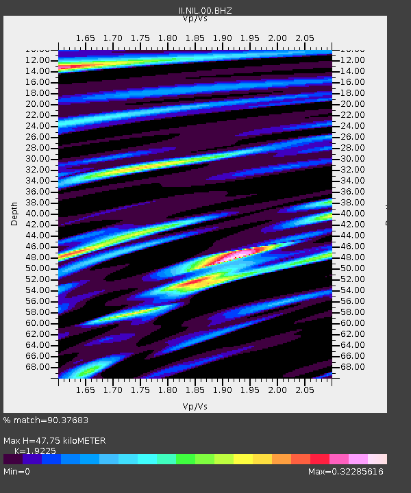
NIL Nilore, Pakistan - Earthquake Result Viewer

Earthquake location: Near East Coast Of Honshu, Japan
Earthquake latitude/longitude: 38.9/141.8
Earthquake time(UTC): 2012/06/17 (169) 20:32:20 GMT
Earthquake Depth: 36 km
Earthquake Magnitude: 6.0 MB, 5.9 MS, 6.3 MW, 6.4 MW
Earthquake Catalog/Contributor: WHDF/NEIC
Network: II Global Seismograph Network (GSN - IRIS/IDA)
Station: NIL Nilore, Pakistan
Lat/Lon: 33.65 N/73.27 E
Elevation: 629 m
Distance: 54.3 deg
Az: 287.144 deg
Baz: 63.335 deg
Ray Param: 0.0654397
Estimated Moho Depth: 47.75 km
Estimated Crust Vp/Vs: 1.92
Assumed Crust Vp: 6.242 km/s
Estimated Crust Vs: 3.247 km/s
Estimated Crust Poisson's Ratio: 0.31
Radial Match: 90.37683 %
Radial Bump: 400
Transverse Match: 75.570404 %
Transverse Bump: 400
SOD ConfigId: 558545
Insert Time: 2013-09-19 20:46:06.917 +0000
GWidth: 2.5
Max Bumps: 400
Tol: 0.001

Signal To Noise

ChannelStoNSTALTA
II:NIL:00:BHZ:20120617T20:41:12.969028Z32.230935.6632866E-61.7570969E-7
II:NIL:00:BH1:20120617T20:41:12.969028Z4.60425146.0251716E-71.3086105E-7
II:NIL:00:BH2:20120617T20:41:12.969028Z8.8744659.242643E-71.0414873E-7
Arrivals
Ps7.4 SECOND
PpPs21 SECOND
PsPs/PpSs29 SECOND