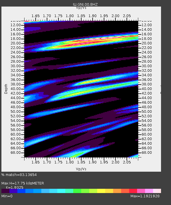
GNI Garni, Armenia - Earthquake Result Viewer
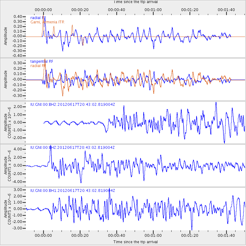
Earthquake location: Near East Coast Of Honshu, Japan
Earthquake latitude/longitude: 38.9/141.8
Earthquake time(UTC): 2012/06/17 (169) 20:32:20 GMT
Earthquake Depth: 36 km
Earthquake Magnitude: 6.0 MB, 5.9 MS, 6.3 MW, 6.4 MW
Earthquake Catalog/Contributor: WHDF/NEIC
Network: IU Global Seismograph Network (GSN - IRIS/USGS)
Station: GNI Garni, Armenia
Lat/Lon: 40.15 N/44.74 E
Elevation: 1609 m
Distance: 70.9 deg
Az: 306.37 deg
Baz: 55.031 deg
Ray Param: 0.05465154
Estimated Moho Depth: 17.75 km
Estimated Crust Vp/Vs: 1.93
Assumed Crust Vp: 6.291 km/s
Estimated Crust Vs: 3.255 km/s
Estimated Crust Poisson's Ratio: 0.32
Radial Match: 83.13654 %
Radial Bump: 400
Transverse Match: 79.399414 %
Transverse Bump: 400
SOD ConfigId: 558545
Insert Time: 2013-09-19 20:46:36.211 +0000
GWidth: 2.5
Max Bumps: 400
Tol: 0.001

Signal To Noise

ChannelStoNSTALTA
IU:GNI:00:BHZ:20120617T20:43:02.819004Z20.989031.6867801E-68.036484E-8
IU:GNI:00:BH1:20120617T20:43:02.819004Z7.54900465.2230007E-76.918794E-8
IU:GNI:00:BH2:20120617T20:43:02.819004Z3.5807194.9853264E-71.3922696E-7
Arrivals
Ps2.7 SECOND
PpPs8.0 SECOND
PsPs/PpSs11 SECOND